Search
Close this search box.

Category: Agriculture

News Archive
An enhanced vegetation index from Landsat imagery

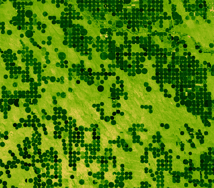
Tracking Agricultural Water Use on a Smartphone

This fall scientists at the University of Nebraska, with partners at Google Inc., the University of Idaho and the Desert Research Institute, introduced the latest evolution of METRIC technology—an application called EEFLUX, which will allow anyone in the world to produce field-scale maps of water consumption.

Read More »
migrating birds

Landsat Helps Feed the Birds

The BirdReturns program, created by The Nature Conservancy of California, is an effort to provide “pop-up habitats” for some of the millions of shorebirds, such as sandpipers and plovers, that migrate each year from their summer breeding grounds in Alaska and Canada to their winter habitats in California, Mexico, Central and South America.

Read More »
An abandoned farmstead in eastern Montana

Modeling a Changing American Landscape

Land change is a signature activity of human civilization. Since the dawn of history, people have purposefully converted natural landscapes to human-dominated areas. Typical motivations for land change are cultivation (e.g. slash-and-burn fields, rice paddies, modern farms); occupation (villages, cities, housing developments); and other cultural and economic pursuits (roads, schools, airports).

Read More »

Landsat and Water: Using Space to Advance Resource Solutions

A recent White House-led assessment found that Landsat is among the Nation’s most critical Earth observing systems, second only to GPS and weather. A new USGS study, Landsat and Water — Case Studies of the Uses and Benefits of Landsat Imagery in Water Resources, provides examples of why Landsat is so valuable.

Read More »

Landsat's Role in Water Resource Management

Water availability and allocation are issues gaining a great deal of attention, particularly in arid climates. Increases in population growth and recent droughts bring urgency to measuring and monitoring water use in areas such as the western United States, where the majority of the water has already been allocated.

Read More »

Remembering Robert B. MacDonald

Earlier this year on Jan. 7, 2014, a giant in the world of Landsat applied science— Robert B. MacDonald—passed away. MacDonald was largely responsible for first envisioning and formulating how to use early Landsat data to estimate global crop production.

Read More »

The Grapes of Landsat

California’s persistent drought is forcing grape growers to keep a more-attentive-than-normal eye on their vines, as water shortages and elevated temperatures alter this year’s growing season.

Read More »

NASS Releases 2013 Geospatial Data for U.S. Crops

The U.S. Department of Agriculture’s (USDA) National Agricultural Statistics Service (NASS) updated its online geospatial exploring tool, CropScape, adding Cropland Data Layers from crop year 2013. This tool gives public an easy access to interactive visualization, geospatial queries and dissemination without the need to download specialized software.

Read More »

NASA Maps Earth's Croplands from Space

It takes a lot of land to grow food for the world’s seven billion people. About a third of Earth’s terrestrial surface is used for agriculture. And about a third of that, in turn, is used to grow crops. Now, a new NASA-funded effort aims to map crop fields worldwide, identify what’s growing where, and determine whether it’s irrigated or fed by rain.

Read More »

Mapping the World with Landsat

Speeding around the Earth at 16,800 mph (27,000 kph), two Landsat satellites are quietly, expertly watching and recording changes in Earth’s lands from space. They are gathering data for people to make maps–all kinds of wonderful maps–of our cities growing, rivers flooding, lava flowing from volcanic eruptions, forests expanding or shrinking, crops greening through the growing season, and even of evidence of pollution.

Read More »

Landsat Impedes Crop Insurance Fraud

With unbiased Landsat imagery as evidence, the U.S. Court of Appeals for the 9th Circuit affirmed an earlier jury-conviction of a northern California farmer found guilty on 16 counts of filing false federal crop insurance claims—scheming the government out of $410, 372.

Read More »

Using Landsat 8 to Locate Fires in Indonesia

In June, air pollution over Singapore and Malaysia spiked as forests in neighboring Sumatra (Indonesia) burned. Using NASA’s daily fire alerts and official national maps, the fires were located in the vicinity of oil palm and acacia tree plantations. However, the coarse resolution of the fire alerts coupled with outdated national maps, made it hard to establish culpability.

Read More »

What is the Economic Value of Satellite Imagery?

Does remote-sensing information, such as that from Landsat and similar Earth-observing satellites, provide economic benefits to society, and can this value be estimated? Using satellite data for northeastern Iowa, U.S. Geological Survey scientists modeled the relations among land uses, agricultural production, and dynamic nitrate (NO3) contamination of aquifers.

Read More »

Landsat Adds Tremendous Value to Decision-Making and Bottom Line

Dr. Stephanie Hulina, President of Geospatial Data Analysis Corporation (GDA Corp) discusses how access to free Landsat imagery from USGS enables her business to provide value-added products to her company’s clients. The long-term continuity of the Landsat mission is essential to her company’s ability to maintain a competitive edge in today’s global economy.

Read More »

Mapping Water Use from Space

[Source: Library of Congress] Dr. Martha Anderson, research scientist, USDA, talks about using images from the Landsat satellite program to monitor water use and drought

Read More »

Landsat Helps Stave Off Crop Insurance Fraud

This February with the help of Landsat a California farmer was found guilty of committing crop insurance fraud in San Joaquin, Contra Costa, and Lassen counties. The farmer was fined $10,000 dollars, ordered to pay $211,516 in restitution, and sentenced to serve two and a half years in prison.

Read More »

Landsat Part of USDA's CropScape Geospatial Data Service

To provide easier access to geospatial satellite products, the U.S. Department of Agriculture’s National Agricultural Statistics Service (NASS) today announced the launch of CropScape, a new cropland exploring service. CropScape provides data users access to a variety of new resources and information, including the 2010 cropland data layer (CDL) just released in conjunction with CropScape.

Read More »

Water Watchers

Dean Stevenson has farmed the plains of south-central Idaho most of his forty-seven years. Like all farmers, he worries about things like the price of

Read More »