
According to aerial surveys conducted by the U. S. Forest Service last summer, the recent California drought resulted in millions of dead trees, mainly in the Sierra Nevada mountain regions of the state.
But a newly published study in the April 2016 issue of the Open Journal of Forestry by scientists at NASA’s Ames Research Center has revealed that forests and woodlands in the Santa Cruz mountains near San Jose and Silicon Valley suffered little or no detectable loss of trees over the past several years. Instead, NASA and the U.S. Geological Survey’s Landsat satellite images over the past three decades showed that the severe drought periods recorded since the 1980s have not slowed rapid tree and shrub growth, especially on steep slopes burned recently by wildfires.
“The data we’re seeing are phenomenal and show nature’s ability to recover from a disaster and repair itself,” said NASA Ames research scientist Christopher Potter. “We thought we’d see very different results, namely some forest dieback due to three recent years of exceptional drought, but we were surprised at these new findings for the mountains west of the San Francisco Bay.”
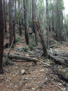
In the charred areas of the Lexington Fire of 1985 and the Summit Fire of 2008 in the mountains of western Santa Clara County, rapidly regrowing shrub and tree stands have experienced an enormous increase in dry woody cover of the past decade that can burn again at any time. The satellite images showed that dense regrowing shrub and young tree cover grew back to nearly 100 percent of its pre-fire density in about five years, putting all housing structures located on steep mountain roads in the Santa Cruz mountains at equal or greater risk for damage from wildfires than was present in the 1980s.
Satellite data for the past 30 years were examined and compared over all mountain ranges of the state. Results showed that the historic drought conditions in 2013 to 2015 did not slow the growth of forests in Santa Cruz Mountain hill slopes, nor they did result in a detectable death of trees, as occurred widely in the southern Sierra region around Yosemite and Kings Canyon National Parks.
“Not all forests respond the same to similar environmental conditions, such as extreme drought,” Potter said. “These forests near the Santa Cruz coast were not hit as hard in 2014 and 2015 by drought as those in the Sierra Nevada Mountains. Also, there is a good deal of low chaparral shrub cover in the Santa Cruz Mountains, which is a plant type evolved to recover quickly from fires by re-sprouting from their burn-resistant roots.”
From a practical standpoint, NASA’s satellite imagery can further pinpoint the likely “hot-spots” of the densest forest cover where future wildfires could spread rapidly in these rugged mountains. This can assist local fire fighters, business and home owners in their efforts to protect older homes nearby and the large new residential estates have been built by commuters to nearby San Jose and Silicon Valley. The best access routes by roads and trails into such hot-spots can be planned in advance of future wildfires, and water tanks and other fire-fighting equipment can be strategically placed nearby.
Further Reading
+ Vegetation Regrowth Following Wildfires in the Santa Cruz Mountains of Northern California Monitored Using Landsat Satellite Image Analysis
+ Landsat Image Analysis of Tree Mortality in the Southern Sierra Nevada Region of California during the 2013-2015 Drought [PDF]

Data in Harmony: NASA’s Harmonized Landsat and Sentinel-2 Project
NASA’s Harmonized Landsat and Sentinel-2 (HLS) project is a groundbreaking initiative that combines data from Landsats 8 & 9 with the European Space Agency’s Sentinel-2A & 2B satellites.


