
First global-scale tool that shows water and land conversion
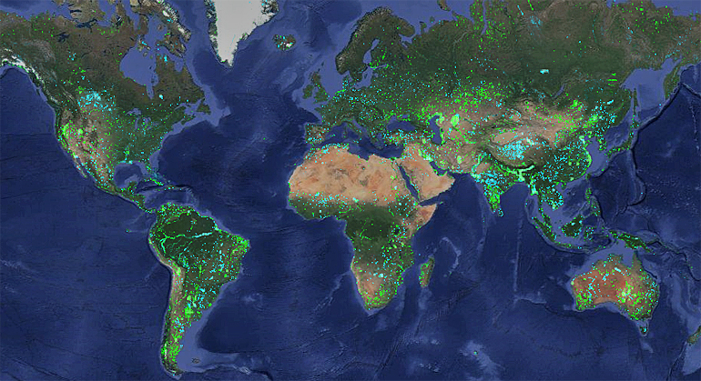
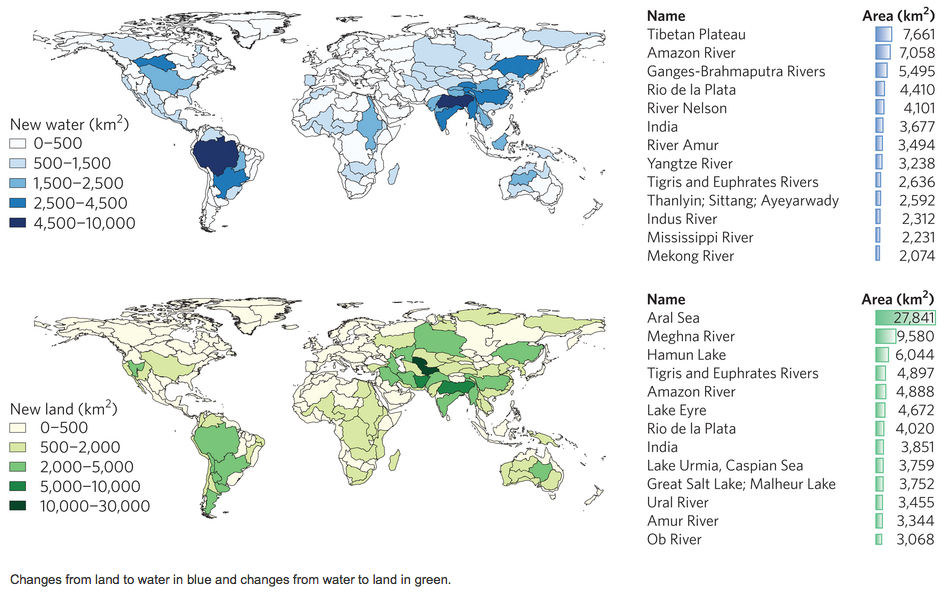
The Deltares Aqua Monitor was developed by Gennadii Donchyts, a remote sensing expert at Deltares. It is the first global-scale tool that shows, with a 30-meter resolution, where water has been transformed into land and vice-versa. The Aqua Monitor uses freely available satellite data, [“it analyses satellite imagery from multiple Landsat missions”], and Google Earth Engine, a platform for the planetary-scale scientific analysis of geospatial datasets that is now open to the general public. Gennadii Donchyts: “The Aqua Monitor shows that, around the world between 1985 and 2015, about 173,000 km2, an area about the size of Washington State, has been transformed into land. At the same time, an area of 115,000 km2 has been transformed into water. Both documented and undocumented changes due to man-made interventions, natural variability, and climate change have now been revealed.”
Known versus unknown
While many countries report on dam construction, information about more remote or isolated areas has been lacking. In Myanmar, the Global Reservoir and Dams database shows an increase in the water surface between 1985 and 2010 of about 400 km2. Using the Aqua Monitor, we found 1,180 km2 of new surface water during the same period. The damming of the Rimjin River in North Korea close to the border with South Korea resulted in a storage surface of 12.4 km2 that was actually due to the Hwanggang Dam, which was thought to be located 35 km to the east. These unknown reservoirs may have had a severe impact on the displacement of people and on the ecology. These issues still have to be investigated.
Created by nature or humans
The results of the Aqua Monitor show only the compound impact of natural and human change or variability. It is often hard to tell what has caused a change without determining the details of the local water and sediment budget. While changes in meanders in the Brahmaputra delta are clearly natural, the Mondrian-like shapes near Taiji Nai’er lakes in China are clearly man-made.
Big data at everyone’s fingertips
Universally-available analytics for big satellite data may have major implications for monitoring capacity and associated actions. At the very local scale, members of the general public can now make assessments without expert assistance if their houses are threatened by coastal erosion. At the regional scale, a downstream riparian state can conduct year-to-year monitoring to see whether upstream neighbours are establishing new impoundments. Finally, at the planetary scale, global agencies such as the United Nations International Strategy for Disaster Reduction can monitor the appearance of new reservoir storage capacity that may reduce flood hazards.
Jaap Kwadijk, the Deltares scientific director: “This has never been done before. So it is difficult to imagine all the new applications that will be made using this tool. But the tool can be used by everybody and so I am sure multiple applications will emerge in the next few years”.
Further Information
+ Deltares Aqua Monitor open tool
+ Earth’s surface water change over the past 30 years, Nature Climate Change (Commentary)
+ Deltares’ Aqua Monitor reveals remarkable changes in global land and water surface, Holland News
+ Observing Water Extent Through Time, Ozius Spatial
+ New Map Shows Where Earth Has Gained and Lost Land, National Geographic


