Observing Earth became more systematic as society became more complex. Long-term observations of Earth’s tides, weather averages, and prevailing winds enabled local sailing conditions to be forecast with increased confidence. Observations of stream water flow were — and still are — crucial to farmers and communities who depend on irrigated crops. During the 18th and 19th centuries, the world’s leading nations sent out extended expeditions in the name of science to observe the oceans, lands, plants, and animals of Earth’s most remote regions. Cook, Humboldt, and Darwin are famous names from this period of Earth observation.
The modern concept of Earth observation is the gathering of detailed information about the planet’s physical, chemical and biological systems by networks of in situ (“in place”) instruments on the ground (e.g. streamgages, seismometers, meteorological stations) and remote sensing technologies positioned in air or space (commonly, photography, radar, or lidar in aircraft; electromagnetic sensors in satellites).
Optimizing resources for Earth observation
Fundamental knowledge of the land and its resources is a basic need for effective government and a productive economy in any nation. More than 30 countries now have Earth observing satellites, reflecting a wide range of national priorities around the world for environmental monitoring and economic growth.
In the United States, the federal government invests about $3.5 billion annually in civil Earth observations and data across multiple agencies, while leveraging related investments that are also made by state, local and tribal governments, academia, and industry. The U.S. government is the largest provider of environmental and Earth-system data in the world. The U.S. Geological Survey, a bureau of the Department of the Interior, is a major contributor to this mission.
The information derived from Earth observations supplies the foundation for scientific advances in many fields and enables numerous federal agencies and partners to carry out their missions. Federal investments in various aspects of Earth observation are conservatively estimated to add $30 billion to the U.S. economy each year by providing Americans with critical knowledge about natural resources, climate and weather, disaster events, land-use change, ecosystem health, ocean trends, and many other phenomena.
Since Earth observation is provided through public funding, the data are made open to the public as much as possible to advance human knowledge and enable private industry to provide value-added commercial services.
As the Nation’s Earth observation capacity has grown, so has the complexity and challenge of assuring its most effective use. In 2010, Congress charged the Director of the Office of Science and Technology Policy (OSTP) with establishing a mechanism to ensure greater coordination among the 11 departments and agencies of the federal government that are funded to conduct Earth observation programs.
In response, OSTP recently released a National Plan for Civil Earth Observations that aims to maximize the value of Earth observation data collected by federal agencies. The Plan is a blueprint for future federal investments and strategic partnerships in Earth observing systems. It lays out federal priorities and supporting actions to manage Earth observation systems through periodic assessments, interagency planning, and international collaboration.
USGS in the National Plan
The plan includes a list of 145 high-impact Earth observation systems. The top 15 systems form a select top tier and are ranked in order of importance, according to carefully identified priorities. USGS systems make up three of the top 15.
First on the prioritized list is the Global Position System (GPS). In second place is the national weather radar network, Next Generation Weather Radar (NEXRAD). The USGS-related programs that follow are Landsat (ranked 3rd), airborne lidar mapping (8th), and the USGS streamgage network (13th).
Landsat
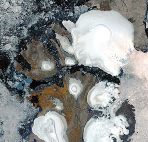
Landsat is a joint effort of USGS and NASA that spans four decades. First launched in 1972, the Landsat series of Earth observing satellites has produced the longest, continuous record of Earth’s land surface as seen from space. NASA launched the latest Landsat mission, Landsat 8, in February 2013. The USGS then assumed ownership and operations of the satellite after a three-month testing period. Landsat 8 works in tandem with the older USGS Landsat 7 satellite to provide data every eight days for any spot on the Earth’s land masses, supporting water managers, agricultural commodities markets, and scientists around the globe.
Earth observation tomorrow
As the world’s population surpasses seven billion people, the influence of human society on the planet is increasing. In fact, scientists often say that the present geologic epoch is the Anthropocene, the age in which humanity has begun to have a significant impact on the planet. Observing the Earth in all its complexity with greater precision and insight than ever before will help us better understand how human activities are affecting vital Earth systems.
A 2007 National Academy of Sciences vision statement speaks to the potential of sustained Earth observation: “Understanding the complex, changing planet on which we live, how it supports life, and how human activities affect its ability to do so in the future is one of the greatest intellectual challenges facing humanity. It is also one of the most important challenges for society as it seeks to achieve prosperity, health, and sustainability.”
Further Reading
+ Full USGS article: Observing Earth Today and Tomorrow: A National Plan
+ National Plan for Civil Earth Observations [PDF]
+ Harnessing Observations and Data about our Earth
+ Sustainable Land Imaging Architecture Study


