
By Laura E.P. Rocchio
In a historical event for NASA’s Goddard Space Flight Center, Queen Elizabeth II of England visited the NASA campus on May 8, 2007. One of the many diplomatic gifts presented to the Queen was a poster commemorating John Smith’s voyage of discovery in 1607 using data from Landsat 7, MODIS, and EO-1.
About the poster:
On December 20, 1606, a group 105 men and boys plus 39 sailors set sail from London, bound for the shores of America, some 4828 kilometers (3000 miles) distant. After 144 days at sea, the three Virginia Company ships made landfall at Cape Henry, Virginia on April 26, 1607. The Company went on to establish Jamestown, the first permanent English settlement in what eventually became the United States of America., In 1608, one of the sailors, Captain John Smith, embarked upon a three-month surveying expedition of North America’s largest estuary, the Chesapeake Bay. With no map or sextant to guide him, Smith relied upon compass and astrolabe for navigation.
This poster celebrates the Virginia Company’s long journey from London to Jamestown and Captain Smith’s exploration of the Chesapeake Bay. The 400th anniversary of Smith’s Voyage of Discovery is commemorated here using data from three of NASA’s Earth imaging sensors.
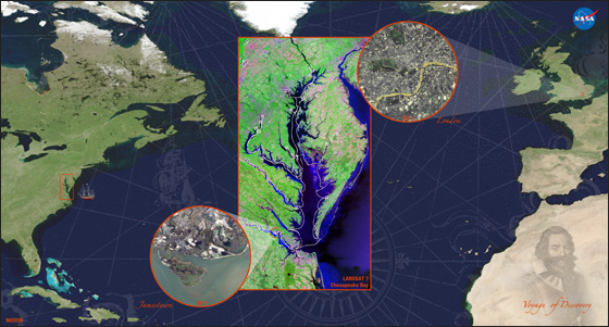
A July 2004 cloud-free mosaic showing the North Atlantic Ocean, eastern North America, and western Europe and Africa, features Moderate Resolution Imaging Spectroradiometer (MODIS) data. The MODIS image serves as the body of this poster and helps to convey the expansive portion of Earth that John Smith and his cohort traversed in 1607.
A Landsat 7 Enhanced Thematic Mapper Plus (ETM+) image of the Chesapeake Bay region is featured in the center. The white line marks the path of Captain Smith’s Chesapeake expedition in a 10 meter long shallop. White crosses indicate locations where Smith and his small cadre of sailors nailed wooden crosses to trees marking the farthest extent of their explorations.
The small circle on the upper right of the bay image features an Earth Observing-1 (EO-1) Advanced Land Imager (ALI) image of central London acquired on February 14, 2001. The opposite circle shows a corresponding image of Jamestown acquired on April 3, 2007.
The rhumb lines across the Atlantic Ocean and the engraving of Captain Smith over Africa are taken from Smith’s 1616 map of New England, the first published map to name America’s northeastern seaboard. A small image of the Susan Constant, the largest of the three Virginia Company ships, can be found near the Chesapeake Bay on the MODIS image.
Captain Smith would surely marvel at the present day map-making capabilities, illustrated here. Today, images such as these, and the data used to create them, are relied upon by many nations to better understand and manage the natural and cultural resources of our planet.


