
The authors argue that “extensive, regular and consistent” satellite measurements are paramount for conducting detailed assessments of biodiversity loss, ecosystem dynamics, forest degradation, and deforestation.
Looking to the Landsat policy, begun in 2008, of free and open access to data, the authors urge the interagency Committee on Earth Observation Satellites to encourage spacefaring nations to adopt a unified open access data policy with “standard imaging specifications and internationally agreed complementary satellite launches to ensure continuous coverage.”
Some article highlights:
“A new era of open-access satellite data has arrived. In 2008, The U.S. Geological Survey released for free to the public its Landsat archive, which dates back to the 1970s and is the world’s largest collection of Earth imagery.”
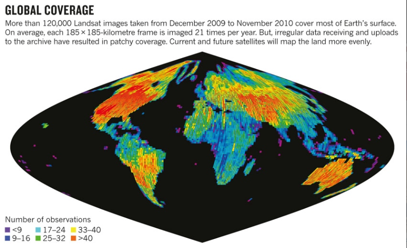
“Landsat data were archived from the outset, but early observing strategies and limitations to on-satellite storage and downlink capacity resulted in uneven global coverage.”
“Usage rocketed in 2008, when Landsat made its images free. More than a million images were downloaded in the first year, compared with a previous annual high of 25,000 images sold. More than 20 million images have been downloaded since the archive opened and the rate continues to increase.”
“Cloud cover, the bane of optical remote sensing, can be overcome by building composite images…This approach is transforming continental and global-scale monitoring.”
“When the archive was opened, there were more Landsat images outside it than in it. Many images were retained by the global network of receiving stations. An effort to consolidate these has added more than 3 million images to the repository since 2010; agreements are in place for a further 2 million to be ingested.”
“Landsat 8 can collect more than 700 images per day—14 times as much as in the 1980s.”
Reference:

Scenes from the Polar Night
Landsat satellites have begun regularly acquiring images of ice at the poles during the winter, with enlightening results.


