


This morning at #AGU15, William Kochtitzky, a student from Dickinson College, presented a poster about glacial changes on Peru’s Nevado Coropuna volcano. We asked him some questions about his research.
Presentation title:
Peruvian Tropical Glacier May Survive Longer Than Previously Thought: Landsat Image Analysis of Nevado Coropuna Ice Cap, Peru
What are the major findings of your research?
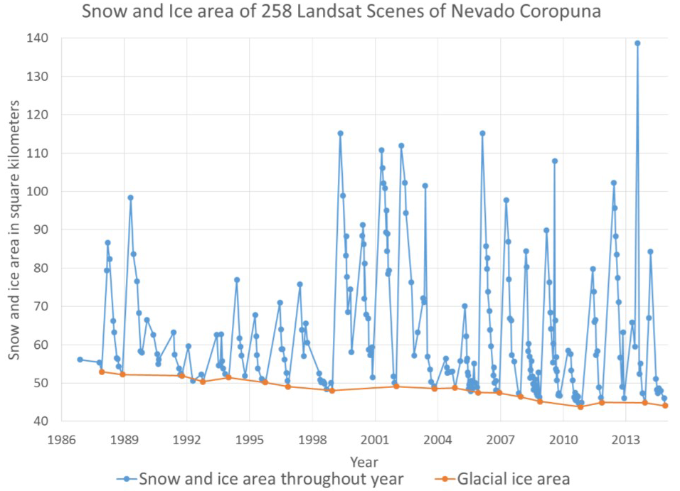
Using Landsat imagery we found that the ice cap of Nevado Coropuna has decreased 24% from 58.0 square kilometers in 1980 to 44.1 square kilometers in 2014. Although previous studies suggest that Coropuna is shrinking at 1.4 square kilometers per year, our analysis suggests that the ice is shrinking at one-third that rate (0.41 square kilometers per year).
This means that ice on Coropuna will not completely disappear in the coming decades as some have feared. Our work shows that care must be taken when selecting satellite imagery for determining the extents of glacierized areas to ensure that snow cover, which can obscure ice boundaries, is at a minimum.
What insight did you gain from Landsat that would have been impossible to glean otherwise?
The Landsat archive provides a temporally extensive data set to study glaciers around the world. As Coropuna is located in an arid tropical environment and is less likely to be obscured by cloud cover, the Landsat archive provides a fantastic way to measure glaciers.
Additionally, due to the age of the archive, we were able to measure snow area, at about a bi-monthly scale, since 1988. This allowed us to have greater confidence in our glacier classification and would not have been possible using other satellites.
Were there challenges merging Landsat and SPOT data?
We did not experience any difficulties combining SPOT and Landsat data. We were able to acquire a SPOT image that was taken within three days of a Landsat scene, allowing us to calibrate our glacier classification scheme and have greater confidence because our SPOT and Landsat images are consistent with each other.
Do you foresee your research having any policy implications in Peru?
This research has the potential for immediate policy implications in Peru. Because previous studies have found that Coropuna is shrinking at a much faster rate than we found using Landsat scenes, the Peruvian government has identified Coropuna as a location in need of adaptation funding. Peruvian government reports suggest that the ice will be a non-contributor to water supply as soon as 2025.
Given our data, we suggest Coropuna will continue to contribute to water supplies for at least several more decades. While Coropuna is still shrinking quickly, the situation is not as dire as we previously thought.
Co-authors:
Benjamin Edwards
Dickinson College
Jersy Marino
Observatorio Vulcanológico del INGEMMET
Nelida Manrique
Observatorio Vulcanológico del INGEMMET
Anyone can freely download Landsat data from the USGS EarthExplorer or LandsatLook.
Further Reading:
+ Landsat at #AGU15
+ Tropical Climate History…Shrinking, NASA Earth Observatory


