
The planet’s oceans are littered with an estimated 3 million shipwrecks; and most maritime mishaps take place close to shore where hazards to navigation—like rocks, reefs, other submerged objects, and vessel congestion—are abundant.
While there is a romantic association of shipwrecks and buried treasure, it is desirable to know where they are located for many other practical reasons. The ships may be of historical significance, or, if the hard substrate of the ship has created a reef, of ecological significance. Modern-era shipwrecks are commonly sources of pollution, leaking onboard fuel and corroded heavy metals. And nearshore shipwrecks can be navigational hazards themselves.
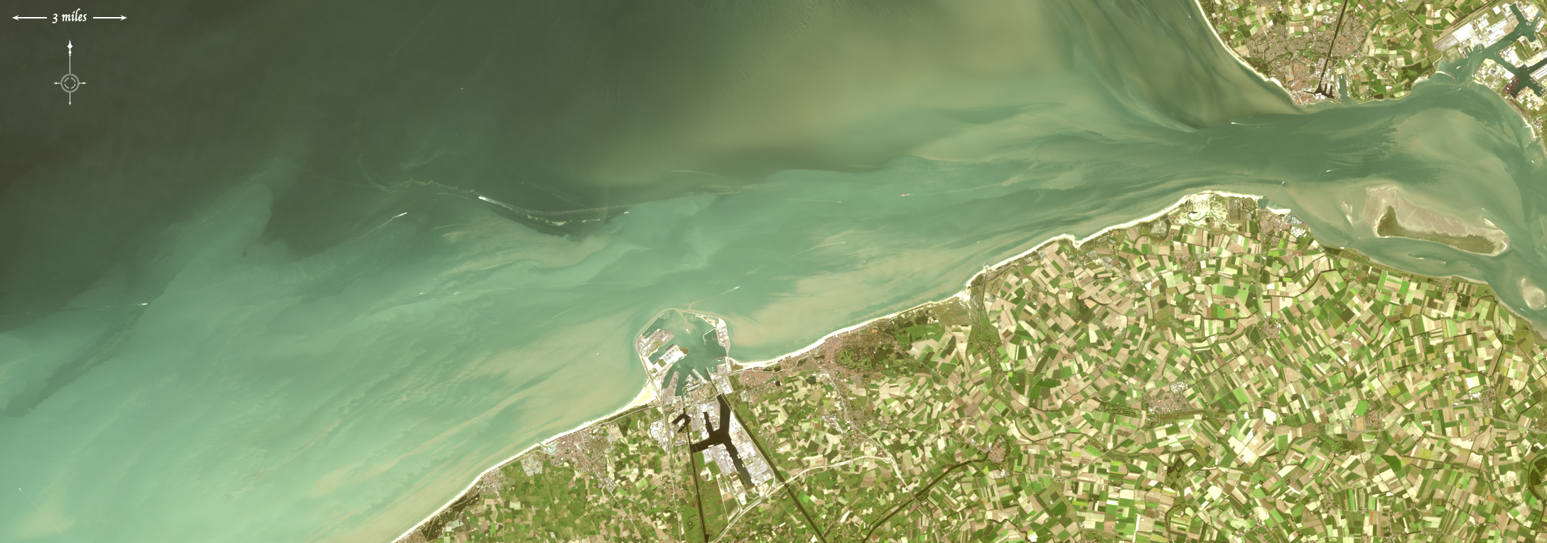
A quarter of all shipwrecks may rest in the North Atlantic; within the North Sea, especially in the narrow southern end where the English coast is merely 100 miles from the shores of Belgium and the Netherlands, World War II-era shipwrecks are plentiful. Here, mines, submarines, submersibles, and warships targeted cargo ships sailing between Allied countries and Dutch and Belgian ports. The potential negative environmental impacts of these modern-era shipwrecks are substantial enough that the Council of Europe’s Parliamentary Assembly has recommended they be mapped and monitored.

A new study published in the Journal of Archaeological Science by authors Matthias Baeye and Michael Fettweis, from the Royal Belgian Institute of Natural Sciences; Rory Quinn from Ulster University in Northern Ireland; and Samuel Deleu from Flemish Hydrography, Agency for Maritime and Coastal Services; is about to change things: the authors have found a way to use freely available Landsat data to detect ships in sediment-laden coastal waters.
Their study was conducted in a coastal area off of the Belgium port of Zeebrugge (the port city for Bruges). The coast is strewn with shipwrecks, often has sediment-laden waters and, most essentially, has a detailed multibeam echosounder survey of the wreck sites (previously conducted by the Flemish government).
Using 21 Landsat 8 images and tidal models, the researchers mapped sediment plumes extending from the wreck locations. They found that the two ships with substantial portions of their structure unburied created sediment plumes that could be traced downstream during ebb and flood tides.
The authors postulate that the exposed structure of these ships created scour pits that then fill with fine sediments (sand, clay, organic matter, etc.) during slack tides (the period of relatively still currents between ebb and flood tides). These scour pits then serve as sediment repositories from which sediments are re-suspended during flood and ebb tides. When these sediments reach the surface, they create their telltale plumes.
This means uncharted shipwrecks could be found using this method—i.e., mapping sediment plumes during various tidal stages and then following the plumes upstream to their point of origin.
This study looked at shipwrecks in waters as deep as 15 m (50 feet); depth is an essential consideration as the re-suspended sediment plumes must reach the surface to be detected by optical satellites like Landsat.
Given that coastal waters are typically shallow, often sediment-laden, and where most shipwrecks occur, this new shipwreck detection method should prove a major discovery for marine archaeologists
Note: The authors used atmospherically corrected Landsat 8 reflectance data, specifically, that of OLI bands 4 (red) and 5 (infrared) to chart sediment plumes.
Science brief by Laura E.P. Rocchio
Reference:
Further Reading
+ Satellites Could Help Discover Modern and Ancient Shipwrecks, Scientific American
+ Detecting shipwrecks from space, Ulster University

Scenes from the Polar Night
Landsat satellites have begun regularly acquiring images of ice at the poles during the winter, with enlightening results.


