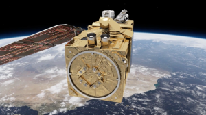
The ESA-USGS collaboration will serve scientific and commercial customers who are interested in the current conditions of forests, crops, and water bodies across large regions and in the longer term environmental condition of the Earth. Data acquired by the European Union’s Sentinel-2A satellite launched in June 2015 are highly complementary to data acquired by USGS/NASA Landsat satellites since 1972.
“Landsat and Sentinel data will weave together very effectively,” said Dr. Virginia Burkett, USGS Associate Director for Climate and Land Use Change. “Adding the image recurrence of two Sentinel-2 satellites to Landsats 7 and 8 will increase repeat multispectral coverage of the Earth’s land areas to every 3 to 4 days. With more frequent views of the Earth, we will significantly improve our ability to see and understand changes taking place across the global landscape.”
The agreement is part of a broader understanding between the European Union and three U.S. federal science agencies — NASA, the National Oceanic and Atmospheric Administration (NOAA), and USGS — that was signed in October 2015. All parties are committed to the principle of full, free and open access to Earth observation satellite data produced by the European Union’s Sentinel program and by the respective U.S. agencies. An ESA article further describes the cross-Atlantic collaboration.
“Free and open access to Landsat and Sentinel-2 data together will create remarkable economic and scientific benefits for people around the globe,” said Dr. Suzette Kimball, Director of the U.S. Geological Survey. “At the outset of our partnership we can only imagine the synergies between our two perspectives from space. But I’m confident that the final product of our partnership will be an enriched knowledge of our planet.”
Sentinel data are available at no cost from the Copernicus Scientific Data Hub. Additionally, in order to expedite data delivery around the globe, users may also download both Sentinel-2 and Landsat data at no charge in a familiar digital environment from USGS access systems such as EarthExplorer. Presently, only selected Sentinel data are available from the USGS in an early testing phase. Timely access to all Sentinel data will follow as the procedures for data transfer, user access, and data delivery continue to be optimized at the USGS Earth Resources Observation and Science (EROS) Center.
The MultiSpectral Instrument (MSI) sensor on board Sentinel 2A acquires 13 spectral bands that parallel and contrast to data acquired by the USGS Landsat 8 Operational Land Imager (OLI) and Landsat 7 Enhanced Thematic Mapper Plus (ETM+). Unlike the Sentinel-2 satellites, Landsat satellites also include a capability to collect thermal infrared data which is used in a variety of water and agricultural monitoring applications. NASA has published an online comparison of Sentinel-2A and Landsat bandwidths.
For technical details such as data availability, geographic coverage, acquisition frequency, and resolution, visit the Copernicus and Landsat websites.
The Landsat program is a joint effort of USGS and NASA. First launched by NASA in 1972, the Landsat series of satellites has produced the longest, continuous record of Earth’s land surface as seen from space. Landsat data were made available to all users free of charge by the U.S. Department of the Interior and USGS in 2008.

Scenes from the Polar Night
Landsat satellites have begun regularly acquiring images of ice at the poles during the winter, with enlightening results.


