Landsat: Seeing in a Different Light
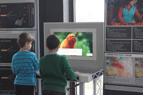
 Landsat: Seeing in a Different Light engages its audience through asking them to select different locations around the world, and then gives the user a scenario where Landsat data is used to solve problems. Exhibit images illustrate that Landsat sees like the audience, while showing that Landsat sees more too. Landsat records thermal, shortwave, and near infrared light that people can’t see. Through comparing images made with visible light to images that include infrared light, the audience is able to understand how these different types of images are useful in different situations that have a real impact on society.
From June through August Landsat: Seeing in a Different Light will is in Vincennes, Indiana at the Knox library. In September, it will travel to the New Mexico Museum of Natural History and Science in time for the Association of Science and Technology Centers (ASTC) annual conference. The exhibit will then be available to other institutions to host.
Are you a museum, library, community center or school interested in hosting this traveling exhibit? Apply now and see Earth as you’ve never seen it before.
+ Download PDF of Main Console (4.7 Mb)
+ Download PDF of Left Panel (2 Mb)
+ Download PDF of Right Panel (2.9 Mb)
Host Site Resources
Soon you’ll be exploring Earth through Landsat satellite images with visitors from your institution. Here you can find information on setting up the exhibit, evaluating the exhibit, and contact information for Landsat’s Education and Public Outreach team.
Education Resources
Landsat has a long history of exploring Earth from Space. Use these resources to learn more about How Landsat Works, How Landsat Benefits Society, and How Landsat’s History continues into the future. Don’t miss the Educational Activities that are available for both formal and informal education settings.


