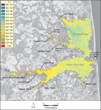
The report, “Locating Ground-Water Discharge Areas in Rehoboth and Indian River Bays and Indian River, Delaware, Using Landsat 7 Imagery,” was prepared by Lillian Wang, geographic information systems specialist and cartographer at DGS, Thomas McKenna, associate professor of geological sciences and associate scientist at DGS, and Tracy DeLiberty, chairperson and associate professor of geography at UD.
“If the discharging groundwater is hotter or colder than the surface water that it discharges into, a thermal anomaly may be detectable in the surface water” Wang said. “In this study, we observed a signature of warmer groundwater discharging into cooler ambient surface water in satellite images collected during the winter.”
The new report, also known as Report of Investigations No. 74 covers Delaware’s Inland Bays in southeastern Sussex County, which are valuable natural resources supporting ecology, tourism, community-based recreation, and fisheries. Nitrogen loading from groundwater discharge to the bays is one of the most difficult environmental problems to quantify.
Wang said groundwater discharge areas were successfully located on the north shore of Rehoboth Bay west of the Lewes and Rehoboth Canal, on Herring and Guinea creeks on the north shore of Indian River and on the north shore of Indian River Bay near Oak Orchard.
“Locating groundwater discharge areas is a critical step towards identifying potential pathways of excess nutrient transport thereby facilitating development of remediation strategies to reduce nutrient loads to the bays,” Wang said.
The report is part of the Delaware Geological Survey’s ongoing mission to understand hydrologic systems and to advise, inform and educate Delawareans about the results of such investigations for use in such areas as water resources, agriculture, public health, economic development, land-use planning, geologic hazards, environmental protection, energy and mineral resources, emergency management and recreation.
Source: University of Delaware, UDaily
Related Links:
+ UDaily press release (external link)
+ UD Report of Investigations No. 74: Locating Ground-Water Discharge Areas in Rehoboth and Indian River Bays and Indian River,Delaware Using Landsat 7 Imagery (7.03 Mb)

Scenes from the Polar Night
Landsat satellites have begun regularly acquiring images of ice at the poles during the winter, with enlightening results.


