
The analysis, released on Earth Day, was requested by the Bahrain Center for Human Rights. The nonprofit center, founded in 2002, has expressed concern that land reclamation and development projects are not benefitting all Bahraini citizens. The center also charges that the development projects have been fueling government corruption.
The AAAS report drew no conclusions regarding access to coastal resources, but it did find “major changes in the land use and land cover of Bahrain that will impact the environment in as yet unknown ways.”
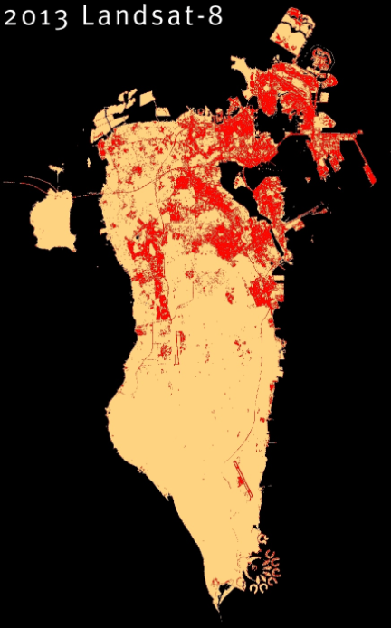
Bahrain is a collection of 36 islands located in the Persian Gulf between Saudi Arabia and Qatar. The largest island, known as Bahrain Island or al-Awal Island, contains the capital city of Manama and the majority of the population and economic activity. The area around Bahrain Island was the primary focus of the AAAS geospatial study, which analyzed images of the country from 1987 to 2013 captured by NASA’s Landsat satellites.
The Landsat images have a spatial resolution of 30 meters so individual pixels in an image may contain several types of ground cover (whether soil, vegetation, water, or built structures) and the analysts must use a computer algorithm to classify the images to a certain degree of accuracy and resolve ambiguities.
The researchers found a substantial loss of natural vegetation in the area around Tubli Bay, directly south of Manama, and in areas west of the city. They also found conversion of land in the west and center of Bahrain Island into agriculture and landscaped vegetation. However, analysis of trends in the total amount of vegetation was inconclusive.
The report found that the land mass of Bahrain expanded about 12.5 percent (from 650 square kilometers in 1987 to 730 square kilometers in 2013) through reclamation and in-filling of coastal areas, including new land added along the northern coast of Bahrain Island and to Muharraq Island. The report also found that the built-up, or urbanized, area of Bahrain more than doubled from 76.2 square kilometers to 155 square kilometers during the study period.
In addition to environmental changes, Bahrain’s also has experienced social and political stresses. A Shiite majority has been seeking more rights from a Sunni monarchy that conquered the island in the 18th century. As reverberations from the Arab Spring reached the nation in 2011, there were bloody clashes as protestors seized a landmark in Manama known as Pearl Square and stayed for weeks.
The new report, “Investigating Land Use and Land Cover Change in Bahrain: 1987-2013,” is now available from the AAAS Geospatial Technologies and Human Rights Project.
Further Reading:
+ AAAS Analysis Finds Major Changes in Land Use and Land Cover in Bahrain
+ Investigating Land Use and Land Cover Change in Bahrain: 1987–2013 [Video and Report]
+ Investigating Land Use and Land Cover Change in Bahrain: 1987–2013 [PDF, 10 Mb]

Scenes from the Polar Night
Landsat satellites have begun regularly acquiring images of ice at the poles during the winter, with enlightening results.


