Evaluating Effects of Land Use Change on Watershed Health and Carbon Sequestration in Costa Rica's Osa Peninsula
This project used Landsat 5 and Landsat 8 data to create land use maps to analyze change in riparian case study areas.

This project used Landsat 5 and Landsat 8 data to create land use maps to analyze change in riparian case study areas.
A combination of lightning, drought and human activity caused fires to scorch more than one-third of Yellowstone National Park in the summer of 1988.
The 2014 megafires in Canada’s Northwest Territories burned 7 million acres of forest, making it one of the most severe fire events in Canadian history.
SDSU post-doc Pedro Oliveira is integrating remote sensing data from airborne LiDAR and Landsat 8 and Sentinel-2 satellites to map the height of the Brazilian Amazon forest canopy.
A new, highly accurate, automated way to detect clouds and their shadows from satellite images over unusually cloudy places.
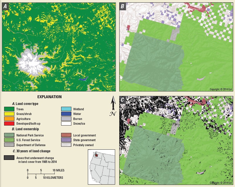
Annual maps of the lower-48 United States produced from Landsat satellite data illustrate how these dynamic systems changed from 1986-2010.
Last spring, NASA researchers flew over the Everglades and Puerto Rico to measure how mangroves and rainforests grow and evolve over time, then hurricanes Irma and Maria struck.
Scientists at Berkeley Lab have produced a rapid mapping of the disturbance intensity across Puerto Rico’s forests with the help of Google Earth Engine and Landsat 8.
Warren Cohen from the USDA Forest Service talks about the value of Landsat’s long history of observations in monitoring and assessing forests.
In this USGS Landsat in Action video Mike Wulder of Canada’s Forest Service talks about the value Landsat images have for mapping and monitoring Canada’s forested areas.

A new program uses Landsat satellite data to automatically categorize what’s on the ground more accurately than other land cover products.
Elmore delves into the changing phenology of forests and how that impacts the amount of carbon dioxide going into the atmosphere.
Researchers used a time series of data from Landsat satellites to quantify areas burned or harvested across Canada.
Thanks to a major effort to ensure full satellite coverage of the world’s forests, all countries now have the necessary data for annual forest monitoring for the first time ever.
The loss of intact forest cover in Myanmar has accelerated in the past decade, according to a study by Smithsonian Conservation Biology Institute scientists and partners.
The data animation based on LandTrendr-derived land cover change illustrates the effects of political boundaries on forest cover as well as the relationship between insect infestations and forest fire behavior.
A new initiative called Land Change Monitoring, Assessment, and Projection provides definitive, timely information on how, why, and where the planet is changing.
Tens-of-thousands of Landsat images representing billions of pixels, were used by White and co-authors to map forest wildfire and harvesting on an annual basis and to then characterize the return of forest vegetation following the disturbance.
Looking at the causes of carbon loss in Pacific Northwest forests.
A Landsat-based continuous mapping method to enable better forest management.
Colombia loses hundreds of km2 of rainforest every year to agriculture and industry.
Twin satellite views show gypsy moth destruction in Rhode Island.
If trees could talk, they would say that Hansen is among their best friends. He is one the world’s foremost forest sentries.
A joint project of University of British Columbia and the Canadian Forest Service—made possible by free and open access to the Landsat archive—has characterized the changes to Canada’s forest between 1985 and 2012.
Valerie Pasquarella, a postdoctoral fellow with the University of Massachusetts Amherst’s Northeast Climate Science Center, recently released a series of new maps showing the magnitude and extent of damage from the current gypsy moth outbreak in southern New England.
A key component of the research is our ability to connect what we see on the ground with what we see from the sky via satellite imagery.
In western North America, mountain pine beetles infest and ravage thousands of acres of forest lands. Landsat satellites bear witness to the onslaught in a way that neither humans nor most other satellites can.
Landsat Science Team member, Mike Wulder, spoke with the International Boreal Forest Research Association last year during their May 2015 conference in Rovaniemi, Finland.
Analyzing a three-decade record of vegetation cover change from the Landsat to compare previous controls on Sierra Nevada forest growth rates and effects of recent fluctuations in water availability since the mid-1980s.
NASA and the U.S. Geological Survey’s Landsat satellite images over the past three decades showed that the severe drought periods recorded since the 1980s have not slowed rapid tree and shrub growth, especially on steep slopes burned recently by wildfires.
Forests are commodities. The biggest driver of deforestation worldwide is the economic value of trees and the land they stand on. With the high demand for agricultural land and wood products, deforestation has become an intractable problem.
