
Dr. Alan Belward describes water changes around Iran’s Karkheh River between 1993-2002.
Alan Belward from the European Union’s Joint Research Center discusses how Landsat helps his team promote sustainable development.
Ted Scambos, Lead Scientist at the National Snow & Ice Data Center, talks about the roll of Landsat in his research studying polar regions.
This week we celebrated the 45th anniversary of the Landsat 1 launch.
In the decades since the Mount St. Helens eruption, scientists have studied the recovery of the ecosystem around the mountain using the Landsat series of satellites.
The data animation based on LandTrendr-derived land cover change illustrates the effects of political boundaries on forest cover as well as the relationship between insect infestations and forest fire behavior.
Scientists are providing a near-real-time view of every large glacier and ice sheet on Earth with Landsat 8.
Landsat Science Team member, Mike Wulder, spoke with the International Boreal Forest Research Association last year during their May 2015 conference in Rovaniemi, Finland.
The Food and Agricultural Organization of the United Nations published an audio article about using geospatial data, including Landsat, to monitor would agriculture on soundcloud.
The BirdReturns program, created by The Nature Conservancy of California, is an effort to provide “pop-up habitats” for some of the millions of shorebirds, such as sandpipers and plovers, that migrate each year from their summer breeding grounds in Alaska and Canada to their winter habitats in California, Mexico, Central and South America.
Tom Loveland, research scientist with the USGS Earth Resources Observation and Science Center, explains how he uses data — both past and present — to help scientists, natural resource managers, and the public better understand how the face of the planet is shifting and what that change means.
On January 24, 2016 Landsat 8 acquired a clear view—from South Carolina to Pennsylvania—the day after a blizzard covered much of the eastern United States in snow. Watch as more than 620 miles (1,000 km) of landscape are shown in detail.
Source: NASA Video @ YouTube South Dakota is the U.S. hotspot for West Nile disease. Scientists and public health officials there developed a way
This fall scientists at the University of Nebraska, with partners at Google Inc., the University of Idaho and the Desert Research Institute, introduced the latest evolution of METRIC technology—an application called EEFLUX, which will allow anyone in the world to produce field-scale maps of water consumption.
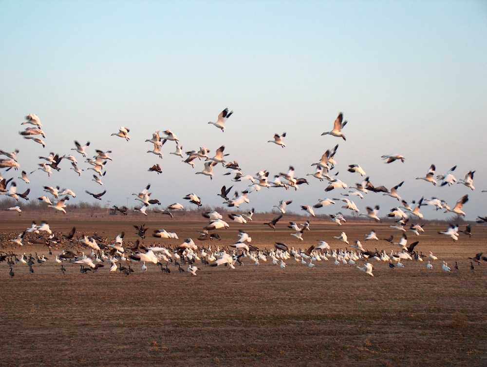
The BirdReturns program, created by The Nature Conservancy of California, is an effort to provide “pop-up habitats” for some of the millions of shorebirds, such as sandpipers and plovers, that migrate each year from their summer breeding grounds in Alaska and Canada to their winter habitats in California, Mexico, Central and South America.
Landsat 8 imagery is being used to identify increased wildfire susceptibility due to the invasion of cheatgrass on rangelands.
The European Space Agency’s Earth from Space, presented by Kelsea Brennan-Wessels from the ESA Web-TV virtual studios, recently featured a Landsat 8 image of the
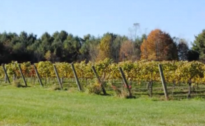
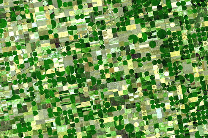
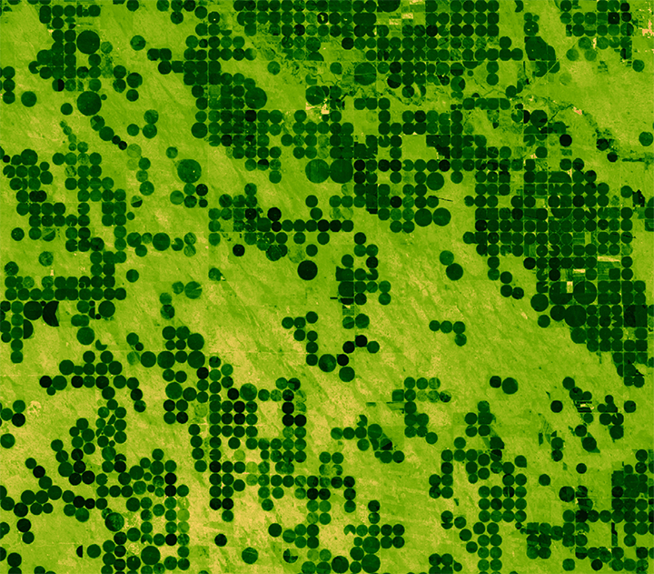
The Virginia Wine Board partnered with Wise DEVELOP to map the extension of Virginia vineyards. Vineyard extent was measured using data from Landsat 8 Operational Land Imager (OLI).
A NASA study of a basin in northwestern Wyoming revealed that the snowmelt season in the area is now ending on average about sixteen days earlier than it did from the 1970s through the 1990s.
On February 11, 2013, the Landsat 8 satellite rocketed into space to extend a four-decade legacy of Earth observations. A few months after launch, we published a composite of images that spanned 9,000 kilometers of land from Russia to South Africa. In celebration of the satellite’s second anniversary, the mosaic concept returns with a chilly twist, this time featuring a slice of the Arctic Circle.
A pulse of water released down the lower reaches of the Colorado River last spring resulted in more than a 40 percent increase in green vegetation where the water flowed, as seen by the Landsat 8 satellite. The March 2014 release of water – an experimental flow implemented under a U.S.-Mexico agreement called “Minute 319” – reversed a 12-year decline in the greenness along the delta.
Explorer Stepan Krasheninnikov first pointed it out in 1755: “Perhaps there is no other region in the world where so many volcanoes and hot springs are to be found in so small a space as here on Kamchatka.” There may not be another land mass on Earth where so many volcanoes and hot springs are crammed into so little space. Situated along the Pacific Coast of Russia, the Kamchatka Peninsula is part of the Ring of Fire, one of the most geologically active zones on the planet. More than 300 volcanoes dot the peninsula, including 29 active ones. And the volcanoes are as diverse–in shape, size, geologic formations, and eruptive styles–as they are numerous.
On July 23rd, 1972, the first Landsat spacecraft launched into orbit. At the time, it was called “Earth Resources Technology Satellite,” or ERTS, and was the first satellite to use a scanning spectrophotometer. Previous satellites relied on film cameras (ejecting the exposed film to be caught by planes) or transmitted the signal from television cameras. The scanning sensor and its successor sensors on subsequent Landsat satellites revolutionized how we study our home planet.
Every full moon, Landsat 8 turns its back on Earth. As the satellite’s orbit takes it to the nighttime side of the planet, Landsat 8 pivots to point at the moon. It scans the distant lunar surface multiple times, then flips back around to continue its task of collecting land-cover information of the sunny side of Earth below. These monthly lunar scans are key to ensuring the land-imaging instrument aboard Landsat 8 is detecting light consistently. For a well-known and stable source of light, nothing on our planet beats the moon, which lacks an atmosphere and has an unchanging surface, barring the odd meteorite.
Google has leveraged the massive amount of data collected about our planet from space over the last four-plus decades—Landsat being one of the key data sets. In this video, Google Earth Engine founder Rebecca Moore shares how Google Earth began and some of the ways it can be used to make sense of decades and petabytes worth of data.
This 40-minute video presentation by Dr. Collin Homer, from the USGS Earth Resources Observation and Science Center (EROS), gives an overview of the latest version of the National Land Cover Database—NLCD 2011—its current status, future plans, and applications examples.
This 1977 NASA video series, “Landsat—Satellite for All Seasons,” provides examples of early Landsat applications.
The Landsat program is the longest continuous global record of Earth observations from space—ever. On July 23, 1972 NASA launched the first satellite in this program, then known as ERTS, the Earth Resources Technology Satellite and later renamed Landsat 1. In 2012, for the 40th birthday of Landsat, NASA edited together selections of an archive video from 1973 about the ERTS launch. Featured in this 1973 video was a senior geologist at NASA, Nicholas Short, and at Dartmouth College, Robert Simpson and David Lindgren. NASA and the U.S. Department of the Interior through the U.S. Geological Survey (USGS) jointly manage Landsat, and the USGS preserves a more than 40-year archive of Landsat images that is freely available over the Internet.
As a Landsat satellite flies over the surface of the Earth the instruments aboard the satellite are able to view a swath 185 kilometers wide and collect images along that swath as the satellite proceeds through its orbit. The spacecraft travels at approximately 4.7 miles per second. The satellite travels from north to south while it’s over the sunlit portion of the Earth, and travels south to north over the dark side of the Earth. One orbit takes about 99 minutes, so that’s about approximately 15 orbits in a 24 hour period.
Covington tells the story of Landsat 5, which was launched in 1984 for a three-year lifetime and was kept alive for nearly 29 years through ingenuity and luck.
In Geneva on January 17, 2014, the Group on Earth Observations (GEO) received unanimous endorsement to unleash the power of open data for a second decade. There was agreement to continue building on the organization’s first 10 years of pioneering environmental advances, which are designed to improve the quality of life of people everywhere. Fueled by open data, GEO’s efforts are now evident in most regions of the world. GEO is comprised of 90 member nations, including the European Commission and 77 Participating Organizations.
In December 2013, the Secretariat Director of the Group on Earth Observations gave a TEDx talk in Barcelona, Spain making the case that all Earth-oberservation data collected from governments and institutions should be open and available to everyone. She illustrates how this could reduce hunger and improve the quality of life of all Earth’s inhabitants. Ryan emphasizes that Earth observation data show Earth without political boundaries, as an entire system.
