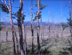
Today at this year’s Fall AGU Meeting, Drs. Cho-ying Huang (National Taiwan University) and William Anderegg (Stanford University) present their findings of a landscape scale assessment of trembling aspen dieback in a 450 square mile study area in southwestern Colorado. Using Landsat data that straddled the drought years (2000-2005) the researchers were able to calculate the amount of non-photosynthetically active vegetation. They found that the sudden aspen decline had increased the non-photosynthetically active vegetation of the region by more than 40 percent (some 40 square miles worth of dead trees where found during the height of the drought in 2002).
Landsat data from 2009 seemed to show forest recovery to pre-drought conditions. However, field investigations revealed that it was mainly a mountain snowberry understory and not aspen that was providing the photosynthetically active vegetation signal and that the aspen of the region have not recovered. The authors’ research illustrates that it is feasible to use Landsat time-series to determine the extent and impact of sudden aspen decline, but they caution that field validation and/or coincident active remote sensing data is necessary when gauging species-specific regrowth.
References:
Cho-ying Huang and William Anderegg, 2011. Recent drought induced increase of non-photosynthetically active vegetation cover in the aspen forests of southern Rocky Mountain. AGU Fall Meeting, 5–9 Dec. 2011, San Francisco, CA, B23C-0437.
Cho-ying Huang and William Anderegg, 2012. Large drought-induced aboveground live biomass losses in southern Rocky Mountain aspen forests. Global Change Biology, in press.

Data in Harmony: NASA’s Harmonized Landsat and Sentinel-2 Project
NASA’s Harmonized Landsat and Sentinel-2 (HLS) project is a groundbreaking initiative that combines data from Landsats 8 & 9 with the European Space Agency’s Sentinel-2A & 2B satellites.


