Source: Heidi Ketler, Virginia Tech News

The study was published in Arid Land Systems: Science and Societies, a special issue of the journal Land.
“There is an incredibly dynamic and complex relationship between land cover types that are constantly changing. Not much is known about what happens in these transitional savanna ecosystems located between more arid and wetter climate zones, information critical to their management,” said lead author J. Tyler Fox, who earned his doctorate in fish and wildlife conservation in Virginia Tech’s College of Natural Resources and Environment in 2016.
“If we can understand how the landscape has changed over decades and what that does to water quality, human health, and ecosystem health, we can begin to make predictions for the future,” said senior author Kathleen Alexander, professor of wildlife conservation in the College of Natural Resources and Environment and a Fralin Life Science Institute affiliate.
The team conducted the study in Alexander’s long-term field site through CARACAL (Centre for Conservation of African Resources: Animals, Communities, and Land Use), a nonprofit organization she and her husband, Mark Vandewalle, established in Northern Botswana. Vandewalle, a co-author of the study, is a wildlife biologist with a focus on ecosystem function in African savanna habitats and serves as CEO of CARACAL.
The study, funded by the National Science Foundation and Forest Conservation Botswana, examined Landsat satellite data from the past 30 years to track broad land cover change in the Chobe district, a 21,000-square-kilometer area encompassing urban, rural, communally managed, and protected land. The Botswana government wanted to better understand how land cover is changing over time and how this might impact ecosystem services.
“The region’s savanna landscapes provide critical resources for both people and animals. Communities in these areas rely heavily on forest resources, such as firewood, thatch for roofs, and plants for food and medicine. These areas are also used in tourism and even in spiritual or cultural ceremonies,” noted Fox, who is currently a post doctoral fellow at the University of Arkansas.
“This study is one of the first to quantitatively examine the loss of forested areas and other land cover changes in savanna environments,” said Richard Yuretich, program director for the National Science Foundation’s Dynamics of Coupled Natural and Human Systems Program, which funded the research. “The complex relationships among climate, ecology, and human activities reveal the overwhelming influence of people on the loss of woodlands. This paves the way for effective management of these diminishing resources.”
The study observed a long-term trend of decreasing woodland cover and increasing shrubland. Grasslands also varied considerably over the study period. Surprisingly, loss of woodlands tended to be higher in protected forest reserves compared with the larger Chobe District.
“We looked specifically at drought, fire, and elephant disturbance as possible causes for these changes,” Fox said.
“Dryland ecosystems are especially vulnerable to human impacts,” Alexander added. “Domestic animals, wildlife, and people congregate in riparian areas near scarce water resources, impacting these regions. Using this approach, we can begin to track change and identify possible drivers, system couplings, and hot spots of degradation. We can see how various stressors are affecting the landscape and begin to engage proactive rather than reactive management approaches.”
According to Vandewalle, many people in Botswana believe that there has been a linear loss of trees, a progression from forested land to shrubs to bare ground.
“Our data, however, reveal extensive regeneration of trees in certain areas in association with the right conditions,” Vandewalle noted. “Change is complex, dynamic, and can be bidirectional in these systems.”
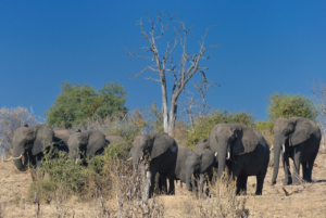
The team also discovered that while many people believe the region’s fast-growing elephant population is a major driver of forest cover loss, there was little evidence for this in their analysis.
Fire, however, was a driving force in land cover change. Fox explained that over a 13-year period, there were nearly 10,000 fires in the Chobe district. More than 85 percent of those happened during a time when there were no storms or lightning, meaning that most of the fires originated from human activities.
“We were able to pinpoint where and when fires were happening, which allowed us to make some fire management suggestions,” Fox said. “For instance, thatch collection activities appear related to fire hotspots, which extended into several of the protected forest reserves. These areas can be more intensively targeted for management and outreach activities. People rely heavily on natural resources extracted from this landscape and need to have sustainable access to those materials to ensure livelihood security.”
Alexander is working with the Botswana government to develop an active monitoring approach based on the groundwork laid by this study.
“Across the globe, forest products remain an essential natural resource,” she said. “We need to understand the status of those resources and identify the primary threats and drivers. Decadal studies of this nature are necessary to understand system dynamics and fundamental to the development of improved and targeted management.”
Alexander also noted that the implications of the study have the potential to benefit not only Botswana, but dryland systems globally.
“Drylands represent over 41 percent of the global landmass and are extremely vulnerable to human impacts,” she added. “What we’re learning in Botswana has application to other drylands that are under increasing threat and pressure to supply human and animal needs.”

Scenes from the Polar Night
Landsat satellites have begun regularly acquiring images of ice at the poles during the winter, with enlightening results.


