
Landsat 8 Used to Pinpoint Shipwrecks
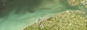
Nearshore shipwrecks can leave telltale sediment plumes at the sea’s surface that reveal their location. Using Landsat 8 data, researchers have detected plumes extending as far as 4 kilometers (~2.5 miles) downstream from shallow shipwreck sites. This discovery demonstrates that Landsat and Landsat-like satellites can be used to locate the watery graves of coastal shipwrecks.
