
Be Part of What’s Next: Emerging Applications of Landsat at AGU24
Anyone making innovative use of Landsat data to meet societal needs today and during coming decades is encouraged to submit and abstract for the upcoming “Emerging Science Applications of Landsat” session at AGU24.
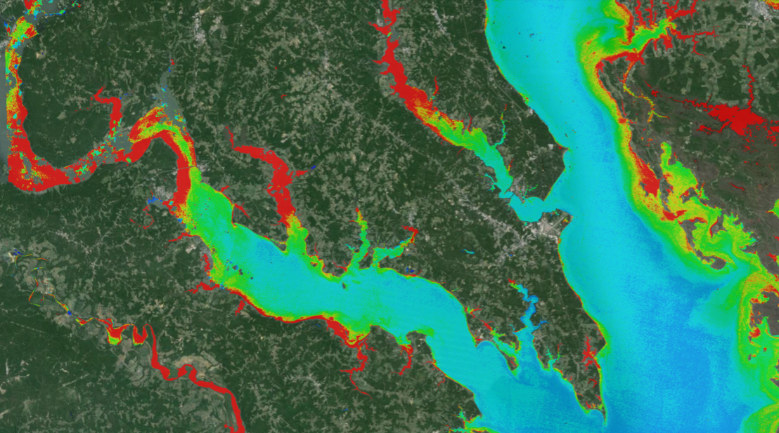
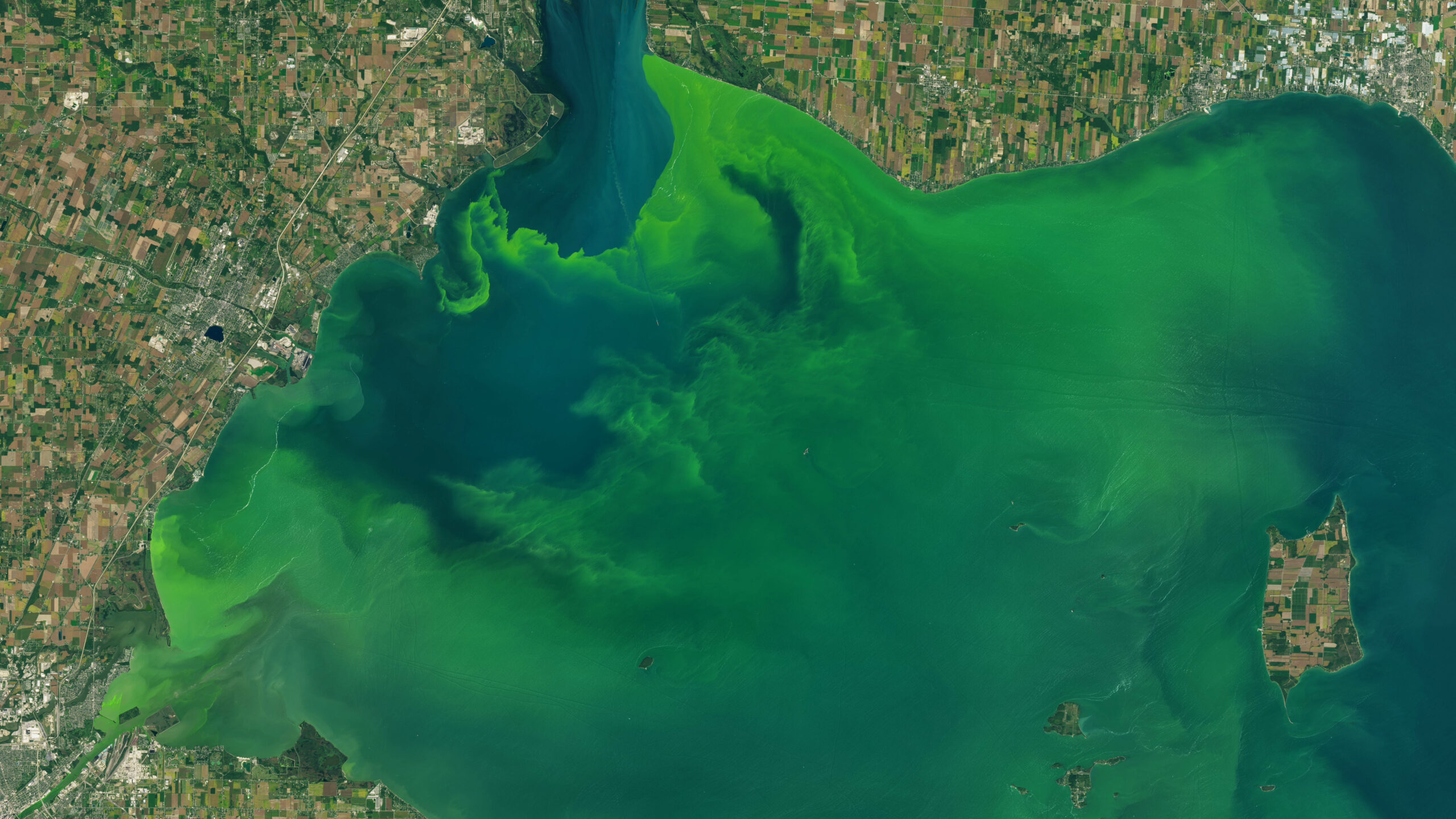
New Tool Provides Rapid Evaluation of Water Quality
A combination of Landsat and Sentinel-2 imagery, NASA near real-time data, and machine learning provides near real-time access to high-resolution water quality maps.
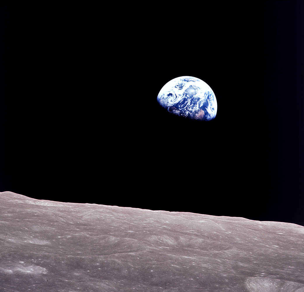
Remembering Bill Anders
Anders, 90, the astronaut who captured the iconic Earthrise photograph, died on June 7, 2024, when the plane he was piloting crashed into the San Juan Channel.

NASA Selects Raytheon Company to Build Landsat Next Instruments
NASA announced in a contract release that Raytheon Company will build the series of Landsat Next instruments. Landsat Next represents a quantum leap in measurement capabilities with improved temporal, spatial, and spectral resolutions.
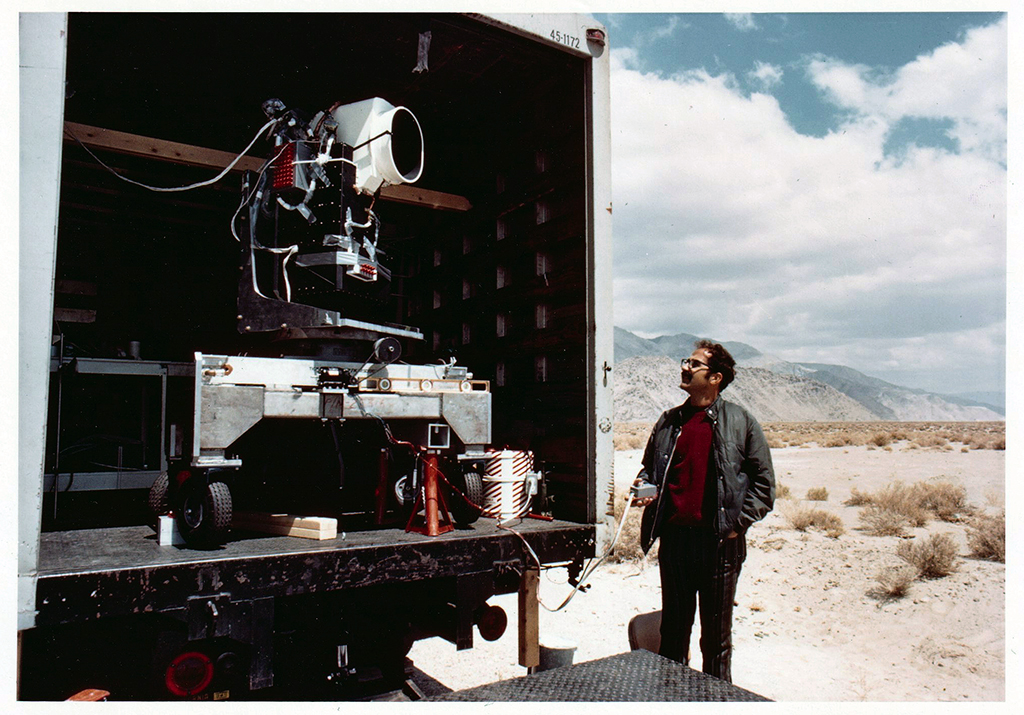
MSS You! Photos from a 1972 Road Trip
Two months before the launch of Landsat 1, the engineering model of the satellite’s multispectral scanner system went on a California road trip.

Landsat Observations Key Resource for Many Federal Agencies
In the FY23 Aeronautics and Space Report released on May 23, 2024, a multitude of Federal agencies report work informed by Landsat data.
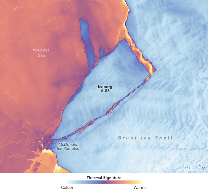
Antarctic Ice Shelf Spawns Iceberg A-83
The Brunt Ice Shelf lost a large wedge of floating ice, the third sizeable iceberg to calve from the shelf in recent years. The TIRS instrument on Landsat 9 captured false-color images of the calving.
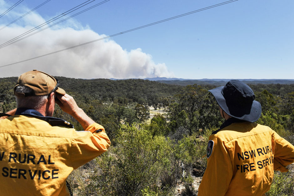
Spotted by Satellite: Situational Awareness in Fiery Times
The Australian company Indji Systems uses a variety of satellite data to provide real-time hazard monitoring and alerts to utility and renewable energy companies across Australia, North America and Europe.
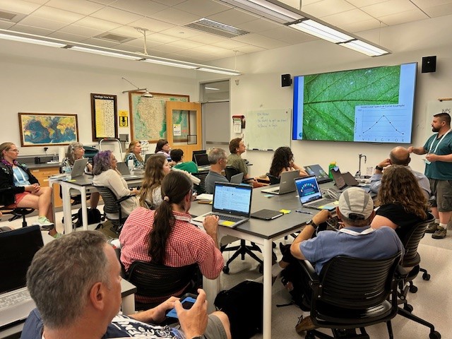
A Rendezvous with Landsat
NASA outreach specialists led educators through a workshop on accessing and utilizing Landsat data at the annual Earth Educators’ Rendezvous.
Be Part of What’s Next: Emerging Applications of Landsat at AGU24
Anyone making innovative use of Landsat data to meet societal needs today and during coming decades is encouraged to submit and abstract for the upcoming “Emerging Science Applications of Landsat” session at AGU24.
New Tool Provides Rapid Evaluation of Water Quality
A combination of Landsat and Sentinel-2 imagery, NASA near real-time data, and machine learning provides near real-time access to high-resolution water quality maps.
Remembering Bill Anders
Anders, 90, the astronaut who captured the iconic Earthrise photograph, died on June 7, 2024, when the plane he was piloting crashed into the San Juan Channel.
NASA Selects Raytheon Company to Build Landsat Next Instruments
NASA announced in a contract release that Raytheon Company will build the series of Landsat Next instruments. Landsat Next represents a quantum leap in measurement capabilities with improved temporal, spatial, and spectral resolutions.
MSS You! Photos from a 1972 Road Trip
Two months before the launch of Landsat 1, the engineering model of the satellite’s multispectral scanner system went on a California road trip.

Satellites to Seeds: NASA Ag Day on the Hill
The Landsat Communications and Public Engagement team supported the Satellites to Seeds event on the Hill in Washington, D.C.

Landsat at Odyssey of the Mind
From May 21-25, the Landsat Outreach team supported Odyssey of the Mind World Finals at Iowa State University in Ames, Iowa.
Landsat Observations Key Resource for Many Federal Agencies
In the FY23 Aeronautics and Space Report released on May 23, 2024, a multitude of Federal agencies report work informed by Landsat data.
A Rendezvous with Landsat
NASA outreach specialists led educators through a workshop on accessing and utilizing Landsat data at the annual Earth Educators’ Rendezvous.
Be Part of What’s Next: Emerging Applications of Landsat at AGU24
Anyone making innovative use of Landsat data to meet societal needs today and during coming decades is encouraged to submit and abstract for the upcoming “Emerging Science Applications of Landsat” session at AGU24.
New Tool Provides Rapid Evaluation of Water Quality
A combination of Landsat and Sentinel-2 imagery, NASA near real-time data, and machine learning provides near real-time access to high-resolution water quality maps.
Remembering Bill Anders
Anders, 90, the astronaut who captured the iconic Earthrise photograph, died on June 7, 2024, when the plane he was piloting crashed into the San Juan Channel.
NASA Selects Raytheon Company to Build Landsat Next Instruments
NASA announced in a contract release that Raytheon Company will build the series of Landsat Next instruments. Landsat Next represents a quantum leap in measurement capabilities with improved temporal, spatial, and spectral resolutions.
MSS You! Photos from a 1972 Road Trip
Two months before the launch of Landsat 1, the engineering model of the satellite’s multispectral scanner system went on a California road trip.
Satellites to Seeds: NASA Ag Day on the Hill
The Landsat Communications and Public Engagement team supported the Satellites to Seeds event on the Hill in Washington, D.C.
Landsat at Odyssey of the Mind
From May 21-25, the Landsat Outreach team supported Odyssey of the Mind World Finals at Iowa State University in Ames, Iowa.
Landsat Observations Key Resource for Many Federal Agencies
In the FY23 Aeronautics and Space Report released on May 23, 2024, a multitude of Federal agencies report work informed by Landsat data.
