
Open Science
Open science is the growing movement to make scientific research, publications, data, and software accessible to everyone. The White House Office of Science and Technology Policy (OSTP) and the National Science and Technology Council (NSTC) define open science as “The principle and practice of making research products available to all, while respecting diverse cultures, maintaining security and privacy, and fostering collaborations, reproducibility, and equity.”
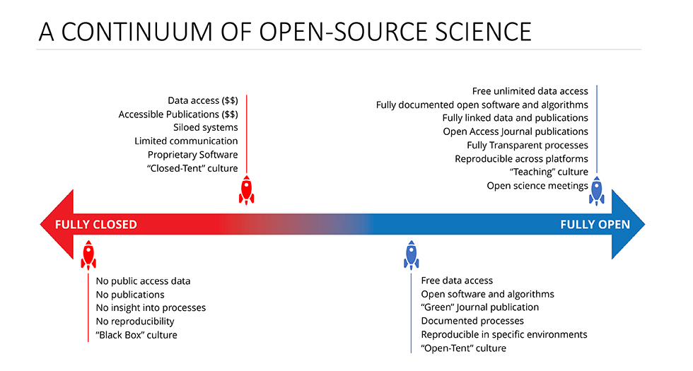
The core principles of open science include transparency, collaboration, and inclusivity. Through these principles, open science represents a transformative approach to conducting science and sharing knowledge. Transparency improves trust in the research process, fosters accountability, and increases opportunities for reproducibility. Collaboration provides access to specialized knowledge and skills, promotes more accurate verification of scientific results, and leads to scientific breakthroughs and discoveries. Collaborative efforts also lead to cost savings through shared productivity, access to pooled resources, and reduced duplication. Inclusivity allows new members of the scientific community to engage in research. It promotes excellence and innovation and encourages efficient problem-solving through diverse perspectives and ideas.
Open Data
A key component of making science more open and transparent is the increased accessibility of open data. Open data is data that is freely available for use, modification, and sharing. Since open data is provided without a financial barrier, more people can access it and explore complementary and inventive methods of analysis. Open data that is already at the disposal of organizations and companies can be analyzed and enhanced by collaborative members of the scientific community, thus contributing to progress and advancements. As research and decision-making become more driven by data, open data practices and policies will be necessary to support informed conclusions and choices. Open data will also play a pivotal role in addressing the complex and interconnected social, environmental, and economic challenges faced by the growing population on Earth.
NASA Open-Source Science Initiative
Open science is a foundational objective of NASA’s Science Mission Directorate. Through the Open-Source Science Initiative, NASA is making a long-term commitment to sharing software, data, and knowledge. The initiative is a comprehensive program of activities that enable and support moving science towards openness, including policy adjustments, supporting open-source software, and enabling cyberinfrastructure. By adopting an open science framework, NASA aims to make research and data more collaborative, accessible, inclusive, and transparent. When properly implemented, it will encourage and empower scientists to address critical environmental issues and accelerate major scientific discoveries.
As with the Landsat Data Distribution Policy, NASA provides unrestricted access to volumes of Earth science data, including Harmonized Landsat Sentinel-2 (HLS) data and HLS-derived data products. NASA’s Earth Science Data Systems (ESDS) Program ensures that these data are fully available to users for any purpose. It promotes and facilitates the open sharing of all metadata, documentation, models, images, and research results, along with the source code used to generate, manipulate, and analyze the data. Along with open data, the ESDS Program provides a range of accessible tools and applications for downloading and processing data.
A Free and Open Landsat Archive
When the Earth Resources Technology Satellite (ERTS) program was officially established by NASA in 1967, William T. Pecora, Project EROS pioneer and then Director of the USGS, firmly believed that the data from the future ERTS-1 (Landsat 1) satellite should be freely available. In 1969, Pecora stated “I believe strongly that the data must be freely available to the resources and scientific communities, on a timely basis; restricted use of the data is not in keeping with the traditions of our Department. This view is shared by our advisory committee in the Academy of Sciences as expressed in their strong recommendation for making the raw data from the satellites rapidly and freely available to the scientific and resources communities.”
While Pecora had this strong belief and recommendation, fees for acquiring ERTS-1 data were implemented when the satellite began returning images of the Earth in 1972. The initial fees were largely charged as a result of processing time and a lack of technological transfer. There were very few image processing programs, and the sizes of the images were considerable for the time. The majority of users were academic scientists and government agencies who had mainframe computers that were capable of processing the data. Those users likely also had funds to purchase images, as the price for one MSS image in 1979 was $200.
With the passage of the Land Remote Sensing Commercialization Act in 1984, the prices increased as a result of transferring Landsat operations to the private sector. The original intention for charging higher fees was to produce enough revenue from commercial imagery sales to support the continuation of the Landsat program. However, the financial obstacles associated with commercialization propelled costs to increase from $650 for one scene to $2,800, and up to $6,000, per scene. With this increase, the demand for imagery sharply declined.
When Congress passed the Land Remote Sensing Policy Act in 1992, the commercialization of the Landsat program eventually ended. In the Act, Congress determined that “the cost of Landsat data has impeded the use of such data for scientific purposes.” Therefore, it was decided that unenhanced Landsat 7 data should be made available to all users at the cost of fulfilling user requests. After Landsat 7 was successfully launched in April 1999, the USGS set the per-scene price of Landsat 7 data at $600, a cost that covered product generation and the distribution of unenhanced data. This reduction drove down commercial fees for Landsat 4 and Landsat 5 data.
As technological advances were made in computer processing and storage, the cost of handling Landsat data significantly decreased. With the development of the internet, data distribution became simpler. These innovations eventually allowed Pecora’s recommendation from 1969 to be realized. In January 2008, Barbara J. Ryan, then Associate Director for Geography at the USGS, and Michael H. Freilich, then Director of the Earth Sciences Division at NASA, signed the Landsat Data Distribution Policy which made Landsat images free to the public. Beginning in July 2008, newly acquired Landsat 7 images became available over the internet at no charge. By December 2008, all Landsat 7 data and Landsat 5 TM data became available, and by February 2009, the entire Landsat data archive became available for download. This unprecedented change was largely driven by Barbara Ryan. She worked for the USGS for more than three decades, and during her years as Associate Director of Geography, she strongly advocated public access to Earth observation data.
NASA Transform to Open Science
On January 11, 2023, the White House OSTP, joined by 10 federal agencies, including NASA, issued a press release announcing new plans to advance open science and equitable research. The announcement officially declared 2023 as the Year of Open Science and outlined a series of actions to unify federal efforts and promote interagency collaboration. While NASA has openly shared data, tools, and resources for several years, renewed goals were established to strengthen a national open science policy, instill open science values, and promote equitable participation in open science.
To accelerate open science practices and major scientific discoveries, NASA launched the Transform to Open Science (TOPS) initiative. TOPS is an ambitious plan designed to cultivate an inclusive culture of open science in agencies, organizations, and communities. Through a 5-year program, TOPS will develop a curriculum to equip participants with the skills required to engage in open science practices; lower barriers to entry for historically excluded communities; and increase understanding and the adoption of open science principles and techniques.
Further Reading
+ Statement of W. T. Pecora, Director, USGS, March 18, 1969
+ Landsat’s Enduring Legacy
+ Imagery for Everyone
+ Free, Open Landsat Data Unleased the Power of Remote Sensing a Decade Ago
+ Benefits of the Free and Open Landsat Data Policy
+ Landsat Science Team Members Support the Free and Open Landsat Data Policy
+ Why NASA and Federal Agencies Are Declaring This the Year of Open Science
+ Open Science Announcements from Federal Agencies
+ NASA Boosts Open Science Through Innovative Training
+ Landsat: An Open Science Approach to Understanding Earth’s Changing Surface
