
Keep Landsat data free and open—this is the resounding takeaway from a recent Remote Sensing of Environment article penned by fourteen members of the 2018-2023 Landsat Science Team. The article, titled “Benefits of the free and open Landsat data policy,” documents how unfettered access to the Landsat archive has enhanced our understanding of Earth, benefited the U.S. and global economy, and strengthened international scientific partnerships.
The authors emphasize that the Landsat archive is the world’s longest running terrestrial satellite record. After the 2008 USGS decision to make Landsat data available at no cost, data use has increased 20-fold, and Landsat-based scientific publications has increased four-fold. The authors posit that the large (and still growing) increase in publications “reflects the scientific community’s uptake of Landsat data for understanding and managing the planet’s resources.”
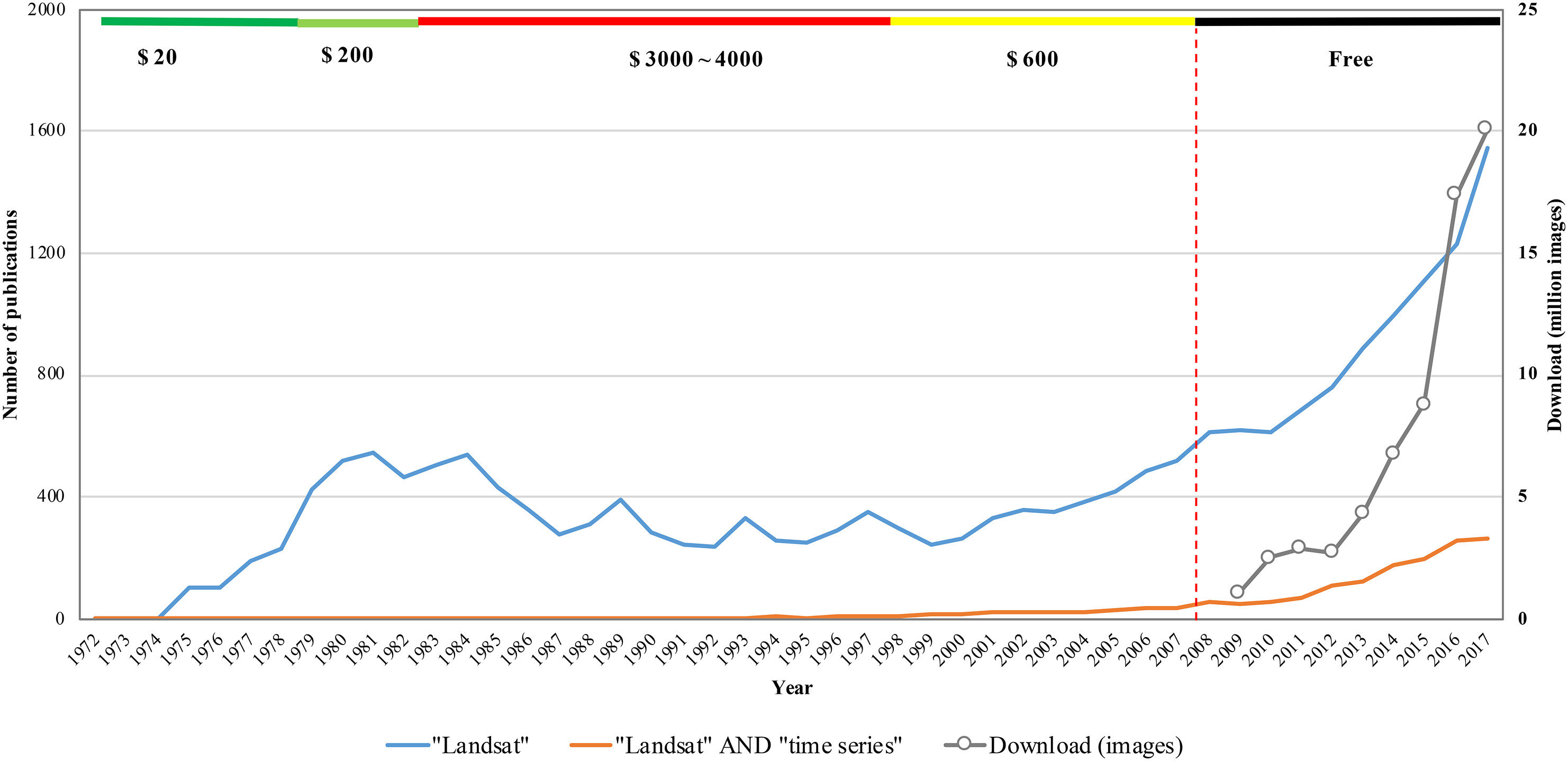
In the paper Dr. Zhe Zhu and co-authors describe how the free and open data policy has allowed researchers to harness the nearly half-century of information contained in the Landsat archive to do robust, global time series analysis—something that was financially unfeasible when there was a charge for the data. They maintain that the open data policy has been to the advantage of the private sector, government, and wider civil society alike.
The authors cite recent studies made possible by the free and open Landsat data policy that have mapped our planet in new and finer-scale ways—global forest extent and annual change maps; global surface water extent maps; global human settlements maps; and multiple global land cover maps. They point out that the 2014 National Science and Technology report that ranked the Landsat satellite program’s importance to society third, just behind GPS and weather satellites and they highlight a 2014 report that estimated the annual economic benefit of Landsat data to U.S. data users as $1.7 billion (in 2011).
The authors stress that the open data policy has supported emerging technologies, non-federal cloud computing services, the creation of analysis-ready dense time-series data cubes, and the realization of “virtual constellations” of international partner satellites.
They emphatically state that loss of the free and open data policy would have a significant impact on the research community. And in this call to action to keep Landsat data free and open, the authors repeat the 2013 National Research Council conclusion that “The economic and scientific benefits to the United States of Landsat imagery far exceed the investment in the systems.”
Reference:
Zhu, Zhe, Michael A. Wulder, David P. Roy, Curtis E. Woodcock, Matthew C. Hansen, Volker C. Radeloff, Sean P. Healey, Crystal Schaaf, Patrick Hostert, Peter Strobl, Jean-Francois Pekel, Leo Lymburner, Nima Pahlevan, and Ted A. Scambos. 2019. “Benefits of the free and open Landsat data policy.” Remote Sensing of Environment224:382-385. doi: https://doi.org/10.1016/j.rse.2019.02.016
Related Reading:
+ What are the Benefits of Landsat’s Current Free and Open Policy? GIS Lounge
+ The US government might charge for satellite data again – here’s why that would be a big mistake, The Conversation
+ A Policy Proposal That Could Curb Remote Sensing Research, UConn Today
Journal article summary by Laura E.P. Rocchio


