
Landsat Next: A New & Revolutionary Mission
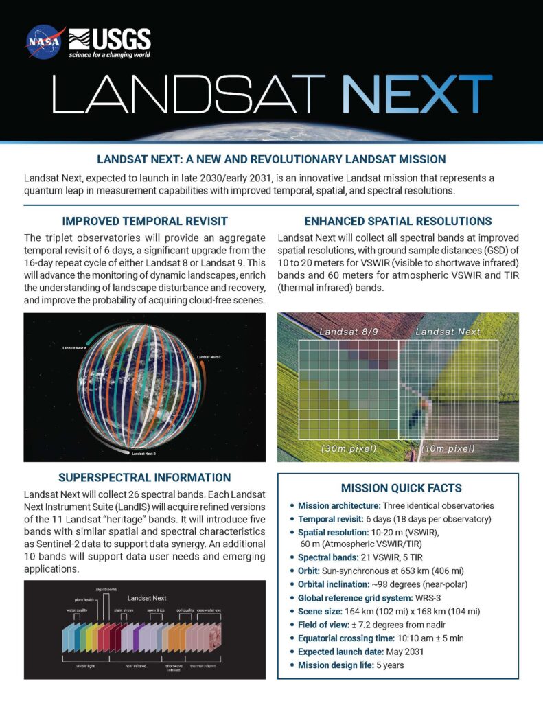
Landsat Next, expected to launch in late 2030/early 2031, is an innovative Landsat mission that represents a quantum leap in measurement capabilities with improved temporal, spatial, and spectral resolutions. The mission will satisfy global Landsat data user needs and support evolving and emerging applications, all while maintaining Landsat data continuity and quality of the longest space-based record of Earth’s land surface.
Video credit: NASA Scientific Visualization Studio, Goddard Space Flight Center.
QUICK FACTS
- Mission architecture: Three identical observatories
- Temporal revisit: 6 days (18 days per observatory)
- Spatial resolution: 10-20 meters (VSWIR), 60 meters (atmospheric VSWIR/TIR)
- Spectral bands: 26 (21 VSWIR, 5 TIR)
- Orbit: Sun-synchronous at 653 km (406 miles)
- Orbital inclination: ~98 degrees
- Observatory orbital separation: 120 degrees
- Equatorial crossing time: 10:10 am ± 5 minutes
- Global reference grid system: WRS-3
- Scene size: 164 km (102 miles) x 168 km (104 miles)
- Field of view: ±7.2 degrees from nadir
- Expected launch date: Late 2030/early 2031
- Mission design life: 5 years
- Mission Category: 2
- Mission Class: B
Improved Temporal Revisit
Landsat Next will be a constellation of three identical observatories sent into orbit on the same launch vehicle. The triplet observatories will be spaced 120 degrees apart at an orbital altitude of 653 kilometers (406 miles).
The Landsat Next triplet will provide an improved collective 6-day temporal revisit, a significant upgrade from the 16-day repeat interval of either Landsat 8 or Landsat 9. The temporal frequency will increase the probability of acquiring cloud-free scenes and enhance the monitoring and management of dynamic and changing landscapes.
Capabilities will include:
- Phenological signatures used for vegetation classification and modeling crop development, health, and yields
- Detect periodic disturbances due to harvesting and episodic insect and disease agents
- Assess near-continuous water use and evapotranspiration
- Provide early warnings about the onset of fires and harmful algal blooms
- Monitor public health during heat wave seasons
- Track dynamics of snow and ice on both land and sea
Side-by-side comparison of Landsat 9 and Landsat Next orbits and ground coverage. Video credit: NASA Scientific Visualization Studio, Goddard Space Flight Center.
Enhanced Spatial Resolutions
Each satellite observatory will consist of a spacecraft with a Landsat Next Instrument Suite (LandIS) that will collect 21 VSWIR and 5 thermal infrared bands. All bands will have higher spatial resolutions than prior Landsat missions, with ground sample distances of 10 to 20 meters for visible, near infrared, and shortwave infrared bands and 60 meters for atmospheric VSWIR and thermal infrared bands.

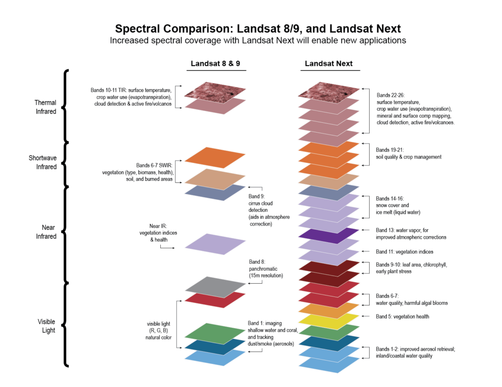
Superspectral Observations
Landsat Next will collect 26 bands—15 more than the currently operational Landsat 8 and Landsat 9 missions. The LandIS on each observatory will acquire refined versions of the 11 Landsat “heritage” bands to maintain data continuity, five new bands with similar spatial and spectral characteristics to the European Space Agency’s Copernicus Sentinel-2 mission to allow for improved data synergy and fusion, and 10 new spectral bands to support data user needs and emerging applications. Landsat Next will also have a water vapor band that will provide for atmospheric correction without ancillary data from other satellites.
LandIS will acquire all bands nearly simultaneously. This will minimize illumination change between bands, facilitating both cloud screen detection and products derived from multispectral surface reflectance and thermal emission data (e.g., evapotranspiration).
Data Quality and Integrity
The historical record of highly calibrated Landsat data has served as a gold standard of global land imaging. Landsat Next will preserve the robust radiometric and geometric accuracy requirements associated with the Landsat program to ensure long-term data consistency and facilitate critical time-series analyses. The radiometric accuracy will be comparable to the signal-to-noise ratios and noise equivalent differential temperatures of Landsat 8 and Landsat 9. The geometric accuracy of previous Landsat missions will match the finer ground sample distances of Landsat Next. Rigorous radiometric and geometric calibration and validation methods will be employed to provide band-to-band and image-to-image registration. Top of atmosphere and surface reflectance data products will be comparable with those from previous Landsat missions.
Landsat for the New Generation
Landsat Next will build upon the Landsat legacy of observing, managing, and adapting to Earth’s changing surface, and will provide expanded capabilities to support evolving and emerging user applications. The enhanced temporal (6-day revisit) and spatial resolution of the new 26-band superspectral Landsat Next constellation will enhance existing Landsat applications and unlock new applications that support:
- Water quality and aquatic health assessments (e.g., harmful algal blooms)
- Crop production and soil conservation (e.g., crop residues and non-photosynthetic vegetation)
- Forest management and monitoring (e.g., photosynthetic bioindicators)
- Climate and snow dynamics research (e.g., snow grain size and albedo)
- Mineral mapping based on thermal emissivity
Landsat Next will continue the Landsat program’s decades-long data record of spaceborne multispectral imagery, which affords global, synoptic, and repetitive coverage of Earth’s land surfaces at a scale where natural and human-induced changes can be detected, differentiated, characterized, and monitored over time.
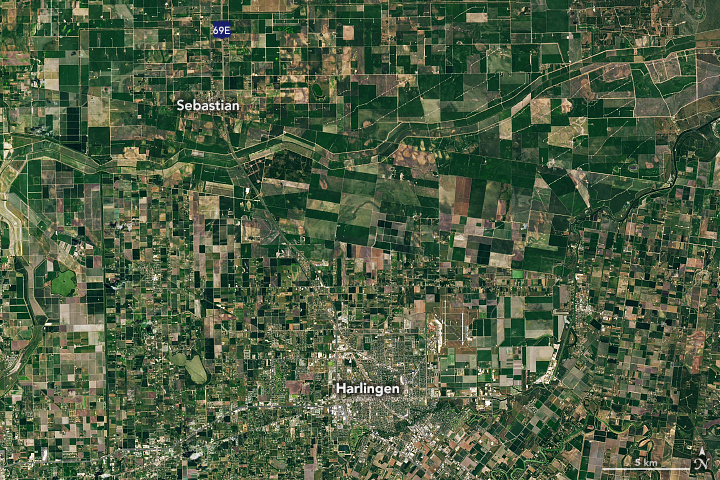

The improved temporal frequency of Landsat Next will increase the probability of acquiring cloud-free scenes and enhance monitoring and management of dynamic and changing landscapes. These two examples demonstrate rapidly changing landscapes. Boll weevils are devastating cotton crops in Texas (left image), but Landsat observations allow farmers to start control efforts early and stop infestations before they become severe and spread. In 2019, intense storms caused major flooding along the Middle Mississippi River (right image), exacerbated by rain, snowmelt, and soil moisture.
Why Landsat Next?
Landsat Next will help us live sustainably on Earth. Landsat Next will propel us into the next half century of scientific discovery and informed decision making. Long-term Earth observations have become more valuable due to growing populations and increased pressures on resources such as food, water, housing, and energy. Tracking global environmental change and natural resources is important for sustaining human needs in the future.
Landsat Next will provide continuity, improve understanding, and support decision making. Landsat Next will continue to provide an unbiased, freely-available, and continuous record of changes on Earth. The longevity of Landsat’s data record enables long-term characterization of environmental changes. Harmonization of Landsat Next data with similar observatories (e.g., Sentinel-2), improving data access through cloud storage and computing, and developing new algorithms will offer the ability for more rapid analyses and decision making.
Landsat Next will result in breakthrough science. New measurements will allow Landsat data users to identify features and patterns that were missed in previous Landsat images due to insufficient temporal, spatial, or spectral resolutions. This may include events that lasted for a very short time (e.g., flood, harvest, snow/ice), features too small to detect (e.g., farm field, deforestation, urban structures), or objects with indistinguishable spectral attributes (e.g., land plants and algal pigments). These scientific discoveries are led by developments in engineering and technology that were not previously available and reflect the overall evolution and improvement in imaging capabilities.
The value of the Landsat program will be magnified with the expanded capabilities of Landsat Next. The new mission will continue to add to the indispensable and extensive data record. It will provide land and ecosystem change data and trending information that would otherwise not be available. With the revolutionary temporal, spectral, and spatial enhancements, Landsat Next will bestow new capabilities to support evolving and emerging applications, and it will assist land managers and policymakers in making more informed decisions about global, regional, and local natural resources and the environment.
