Search
Close this search box.

Landsat Observations Key Resource for Many Federal Agencies

Landsat Observations Key Resource for Many Federal Agencies

Title page of the Aeronautics and Space Report of the President for FY23.
Title page of the Aeronautics and Space Report of the President Fiscal Year 2023 Activities.

Last week the Aeronautics and Space Report of the President for fiscal year 2023 was released.  


The report—mandated with the 1958 founding of NASA—highlights aerospace activities and accomplishments of 14 federal agencies and departments each year.


The U.S. government is a major consumer of information provided by space-based Earth-observing satellites. Agencies regularly turn to satellite data for actionable information that is relevant to their missions.


In the report released on May 23, 2024, the Department of the Interior’s U.S. Geological Survey, Bureau of Land Management, and National Park Service, along with the U.S. Department of Agriculture’s Agricultural Research Service, National Agricultural Statistics Service, Risk Management Agency, Foreign Agricultural Service, and Forest Service all report work informed by Landsat data.

A map of the U.S. showing different land-cover types in an assortment of colors.
The land cover layer from the 2021 National Land Cover Database feature in the FY23 report.

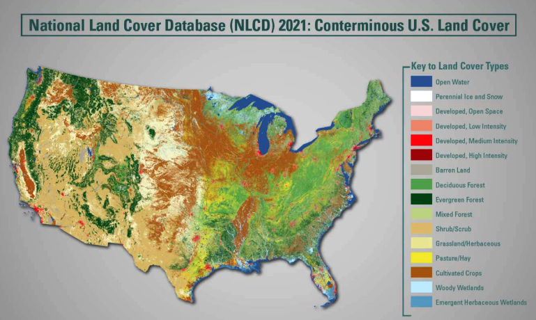
Landsat data is regularly used by these agencies to perform regular updates of operational products such as the National Land Cover Database and LANDFIRE.

Landsat is also a crucial resource for emerging applications such as Lake Trophic State mapping, the creation of provisional science data products like Aquatic Reflectance and actual evapotranspiration (ETa, which is the quantity of water removed from Earth’s surface—a fundamental factor in global water use monitoring); the creation of an iron index to assess iron oxide-strained waterways; and for new machine-learning techniques used to identify exotic annual grass abundance (in concert with HLS).

Department of Interior Reported Uses of Landsat

The U.S. Geological Survey (USGS)—in addition to operating the Landsat satellites and processing, archiving, and distributing their data—is also a major user of Landsat.

In FY23, USGS used Landsat data to monitor lake clarity, calculate fire history metrics for the conterminous U.S., better understand invasive species extent and growth patterns, monitor water use, quantify rangeland health conditions, and investigate the history of clear streams that suddenly turn rust-colored in northern Alaska.

An iron-colored Tukpahlearik Creek running through northwest Alaska, adjacent to Kobuk Valley National Park and north of the Arctic Circle.
A iron-colored Tukpahlearik Creek, captured by Landsat 9 on July 23, 2023. The creek runs through northwest Alaska, adjacent to Kobuk Valley National Park and north of the Arctic Circle. Image credit: NASA/USGS Landsat; NASA's Earth Observatory

The National Park Service used Landsat data to quantify glacier ice cover change, document land cover shifts in national parks, and to map large fires as part of the Monitoring Trends in Burn Severity project.

Department of Agriculture Reported Uses of Landsat

U.S. Department of Agriculture uses Landsat data regularly. In FY23, its Agricultural Research Service (ARS) used Landsat combined with Sentinel-2 data to support almond, grape, and grazing projects. The National Agricultural Statistics Service (NASS) used Landsat and Sentinel-2 data to estimate crop acreage at the state and county level.

The Risk Management Agency (RMA) used Landsat and other satellites to provide situational awareness in times of disaster. The Foreign Agriculture Service (FAS) used Landsat and Sentinel-2 to map type and crop area around the world.

The U.S. Forest Service (USFS) used Landsat combined with Sentinel-2 to conduct forest damage evaluations, create emergency assessment maps of burn severity for 79 wildland fires that supported post-fire stabilization and hazard mitigation. Landsat and Sentinel-2 data were also used operationally by USFS to map canopy cover loss for 92 large wildfires in support of forest restoration planning. Historic Landsat data was used to map the location, size, and severity of 888 current and historical fires impacting close to 7 million acres of public and private land. USFS also worked on an operational Landsat active fire detection for Canada, Mexico, and the continental U.S.

Landsat together with aerial photos were used by USFS to update vegetation, riparian, and land cover change maps. Landsat was also used to create annual updates of U.S. canopy cover, and to inform land-type and soil-type mapping used by both USFS and the Natural Resources Conservation Service.

Landsat time series data within Google Earth Engine was used by USFS and partner agencies to create a land-cover and land-use monitoring system known as the Landscape Change Monitoring System. USFS also used a suite of satellite data including Landsat to support their forest inventory and monitoring, and to continue work on national carbon reporting.

Our Rapidly Evolving Planet

In the report, NASA’s Earth Science Division shared its goal to identify and make observations that help “understand our rapidly evolving planet through the coming decades.”

As an example, mention was made of a May 2023 Science article that used nine different altimetry data sets (ICESat, ICESat-2, CryoSat-2, ENVISAT, Jason series 1-3, SARAL, and Sentinel-3) in combination with nearly a quarter-million Landsat images to examine Earth’s lake water storage over three decades. The researchers found that more than half of the planet’s largest lakes declined between 1992 and 2020. They attributed the loss of water volume in natural lakes to climate change and human consumption, and reservoir losses to sedimentation—significant findings for sustainable water resource management.

Banner Image Caption: Maui's Lahaina fire as seen by Landsat 8 at 10:25 p.m. local time on August 8, 2023 and used on the FY23 Aeronautics and Space Report's title page. Much of Lahaina, a town with a resident population of nearly 13,000 people, appeared to be on fire at the time of the image. Image credit: NASA/USGS Landsat; NASA's Earth Observatory

On Key

Recent Posts

On Key

Related Posts