

Unleashing Climate Data and Innovation for more Resilient Ecosystems
Ecosystems provide vast services and benefits to humankind: food and water that is needed for survival; nutrients and other natural products that fuel farms and industries; natural controls on many pests and pathogens; storage of carbon safely out of the atmosphere; shared spaces for tourism and recreation; and sanctuaries that preserve biodiversity, natural beauty, and cultural history.
Mapping South Asia's Mangroves
Along the sea’s edge in Bangladesh, India, Pakistan, and Sri Lanka, the dense coastal population lives largely in symbiosis with the region’s mangrove forests.
Mangroves—a vast network of intertidal trees and shrubs with their characteristic tangle of above ground roots—give safety, sustenance, and spectacle to coastal denizens in a multitude of ways. Namely, by stabilizing shorelines, safeguarding water quality, influencing stable microclimates, controlling flooding, and providing transportation, forest products, hunting and fishing grounds, and recreation and protecting people and property from storms.
A Closer Look at Old-Growth Forest Loss in Indonesia
A group of researchers from the University of Maryland, the Indonesian Ministry of Forestry, and the World Resource Institute joined forces to remedy the lack of consensus about the amount of old-growth forest clearing occurring in Indonesia.
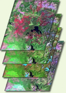
Insights Provided by New Compendium of Land Cover Mapping Satellites
A compendium of civilian satellites with the potential to image global land surfaces has been compiled by Alan Belward and Jon Skøien from the Land Resource Management Unit of the European Commission’s Institute for Environment and Sustainability. Results of this work were published online on April 28, 2014 in the Journal of Photogrammetry and Remote Sensing.
Nearly 200,000 Glaciers Mapped for Better Sea Level Rise Estimates
An international team led by glaciologists from the University of Colorado Boulder and Trent University in Ontario, Canada has completed the first mapping of virtually all of the world’s glaciers—including their locations and sizes—allowing for calculations of their volumes and ongoing contributions to global sea rise as the world warms.
Forest Monitoring: Bringing the Power to the People
Forest conservation is an issue of major concern to communities large and small around the globe. But gathering the monitoring data needed to make the right decisions has proven extremely prohibitive for individuals to entire governments.
