Landsat’s Role in Managing Ecosystems and Biodiversity
Our world is made of complex networks of living things and physical elements that constantly interact and affect each other. Such networks are known as “ecosystems.” Healthy and economically important ecosystems such as temperate forests, wetlands, grasslands, coastal zones, coral reefs, and rainforests all play roles in human life. For example, farm and rangeland ecosystems must be healthy to produce the grains and livestock on which we depend as a nation. Marine ecosystems depend on the health of land ecosystems, because coastal areas provide habitat needed to support the productivity and diversity of aquatic organisms. Landsat has brought valuable capabilities to ecosystem studies. Landsat instruments measure reflected light in visible and infrared wavelengths. Because plants reflect little visible light and a lot of infrared light when they are healthy, the measurement of both types of light simultaneously gives scientists a way to assess plant health and density over a landscape. Measurements are detailed enough while still covering a wide area that ecologists can expand their interpretations of local events and processes, such as an insect infestation in a specific forest, to a regional scale. This helps them to gauge the health of larger ecosystems. Because Landsat data are accurately mapped to reference points on the ground and adjusted for topographic relief, they can be integrated with other geographic data sets and models to explore more complex studies of ecosystems and biodiversity across space and time.

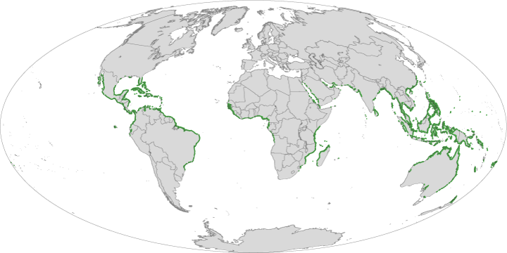
Landsat Enables World’s Most Comprehensive Mangrove Assessment
The most definitive map of Earth’s mangrove forests has been created with Landsat data. A group of scientists, led by Chandra Giri from USGS-EROS, has calculated that approximately 53,190 square
Lasers Together with Landsat Help Researchers Predict Birds' Preferred Habitat
Every spring, migratory birds like the Black-throated Blue Warbler journey from tropical Caribbean or South American refuges to North American forests. But which forest patch will they call home this
Extreme Weather Impacts Migratory Birds
Every year, hurricanes and droughts wreak havoc on human lives and property around the world. And according to a pair of new NASA-funded studies, migratory birds also experience severe impacts
Ecosystem, Vegetation Affect Intensity of Urban Heat Island Effect
NASA researchers studying urban landscapes have found that the intensity of the “heat island” created by a city depends on the ecosystem it replaced and on the regional climate. Urban
Landsat’s Role in Chesapeake Bay Management
• John Smith’s Bay Then & Now – When Captain John Smith first explored the Chesapeake Bay in 1607, the “Great Shellfish Bay,” as it was called by the Algonquian
Landsat Tracks Down A Pesky Weed in Australia
Source: Minister for Primary Industries and Fisheries, Australia Queensland scientists are using satellite technology to help manage one of Australia’s most damaging weeds. “This a world first,’’ Minister for Primary