Mapping the Mighty Mangrove
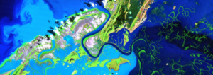
A new longitudinal study from Australia has harnessed thirty years of NASA/USGS Landsat data to map the nationwide movement and migration of mangrove forests.

A new longitudinal study from Australia has harnessed thirty years of NASA/USGS Landsat data to map the nationwide movement and migration of mangrove forests.
