![Morgan Crowley](https://landsat.gsfc.nasa.gov/wp-content/uploads/2022/08/CrowleyM.jpg)
50 Years, 50 Stories: Morgan A. Crowley
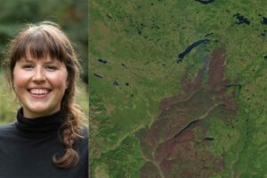
In my Ph.D. research at McGill University in Canada, I used Landsat data to map fire progressions for Canadian wildfires.
The 22nd William T. Pecora Memorial Remote Sensing Symposium (Pecora 22) will convene in Denver, Colorado, USA from October 23 – 28, 2022, and will focus on all aspects of Earth observation, spanning scientific discoveries to operational applications, and from sensors to decisions.