Data Wrangling with Dana Ostrenga
Data interoperability expert Dana Ostrenga explains how government and commercial Earth observation satellites provide broader support to the scientific community when used together.

Data interoperability expert Dana Ostrenga explains how government and commercial Earth observation satellites provide broader support to the scientific community when used together.

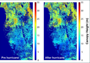
Rising sea levels and increased ocean temperatures are supercharging hurricanes. Using satellite data can help monitor vulnerable ecosystems.

Why do we calibrate Landsat data? We spoke with Brian Markham, a key figure of Landsat calibration science for four decades. He said that it all comes down to this: “If we’re using a system to quantify changes on the Earth, we must make sure the system we’re using is not changing.”

Data interoperability expert Dana Ostrenga explains how government and commercial Earth observation satellites provide broader support to the scientific community when used together.

Rising sea levels and increased ocean temperatures are supercharging hurricanes. Using satellite data can help monitor vulnerable ecosystems.