
Landsat Cultivates Fans Among Midwest Farmers
Contributor: Gretchen Cook-Anderson, NASA Earth Science News Team Noreen Thomas’ farm looks like a patchwork quilt. Fields change hue with the season and with the alternating plots of organic wheat, soybeans,
Landsat-Based Water-Use Mapping Method Hailed as an Important American Government Innovation
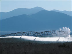
In the dry Western states, where irrigated agriculture accounts for 86% of all water consumption, the water-use (evapotranspiration or ET) information provided by METRIC is critical for arbitrating increasingly common water-resource conflicts.
Researchers Estimate Vineyard Area Using Landsat
In a study published in the Spanish Journal of Agricultural Research, Spanish researchers demonstrate that Landsat data can be used to locate vineyards and estimate their relative area. This work
New Landsat-Based Maps of Complex Caribbean Islands Reveal Conservation Opportunities Where Sugar Cane Cultivation Has Become Unprofitable
A new set of vegetation maps for five islands of the Caribbean Lesser Antilles, including Grenada, St. Kitts, Nevis, St. Eustatius and Barbados, appear in the June issue of the
Precious Resources: Water & Landsat’s Thermal Band
Like most decisions, political and otherwise, having a thermal band on future Landsat missions is a matter of money. In order to show the intrinsic worth of a thermal band, water managers have attempted to quantify the monetary benefits of the improved water efficiency made possible with thermal data from Landsat.
Landsat – Protecting the Price of Bread
Landsat satellite data are behind the accurate global crop production estimates that enable such price stability.