

Mapping the World with Landsat
Speeding around the Earth at 16,800 mph (27,000 kph), two Landsat satellites are quietly, expertly watching and recording changes in Earth’s lands from space. They are gathering data for people to make maps–all kinds of wonderful maps–of our cities growing, rivers flooding, lava flowing from volcanic eruptions, forests expanding or shrinking, crops greening through the growing season, and even of evidence of pollution.
Vast Water Reserves Found in Drought-Prone Northern Kenya
Large underground water reserves have been found in Turkana, one of Kenya’s driest and poorest regions. The discoveries were made by the natural resources exploration firm, Radar Technologies International, during the course of a survey of groundwater conducted for the Kenyan Government on behalf of the UN. The aquifers were detected with the WATEX System, RTI’s state-of-the-art, space-based exploration technology.
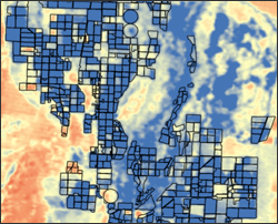
Mapping Water Use from Space
[Source: Library of Congress] Dr. Martha Anderson, research scientist, USDA, talks about using images from the Landsat satellite program to monitor water use and drought on U.S. farms with pinpoint
Changing Precipitation Patterns Impacting Tibetan Plateau Glaciers
In the July issue of Nature Climate Change, Tandong Yao and colleagues report on the changing status of Tibetan Plateau glaciers over the past three decades. Using an array of data
Landsat can be an Impartial Arbitrator in Water Conflict Issues
Speaking at an important state-wide water summit in March, Nevada Governor Brian Sandoval lauded DRI’s METRIC program calling its Landsat satellite technology an important tool in monitoring water usage.
World Water Day
http://www.youtube.com/embed/c6OmfYEgzA0 Water is an essential resource for food cultivation. With 7 billion humans to feed, efficiently managing the planet’s water supply is essential. On March 22, 2012 the UN celebrates World
