
Overall, the RTI study found that Turkana hosts a minimum reserve of 250 billion cubic meters of water, which is recharged mainly by the rainfalls of the Kenyan and Ugandan highlands at a rate of 3.4 billion cubic meters per year. This new wealth of water could boost Kenya’s share of available water by 17% and alone represents nearly double the amount of water that Kenyans consume today. This groundwater raises the prospect for improving the livelihoods of the Turkana people, most of whom live in poverty and have limited access to basic services and clean water.
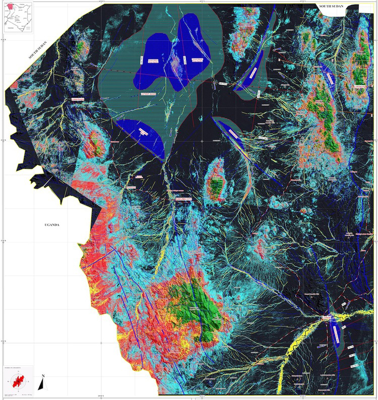
Two major aquifers have been recorded and proven by drilling. The large Lotikipi Basin Aquifer is estimated to store 207 billion cubic meters of water, the same volume of the nearby Lake Turkana. About the size of the US state of Rhode Island, the aquifer replenishes at a rate of 1.2 billion cubic meters a year. This paleo lake could be part of the “Land of Marvels”, the ancient sources of the Nile that were explored by Queen Hatshepsut some 3,500 years ago.
The Lodwar Basin Aquifer, is situated within a short distance of Lodwar town and Turkana’s oil reserves. It is fed by the perennial Turkwel River and has an estimated reserve of 10 billion cubic meters. RTI recorded three other large structures – Gatome, Kachoda and Nakalale – which could prove to store an combined 30 billion cubic meters once confirmed by drilling.
In addition to deep reserves, RTI also mapped 2 billion cubic meters of water passing only a few meters under the ground and easy to reach, significantly raising the prospect for local agriculture activities.
Looking ahead, RTI has recommended that all measures be taken to ensure the sustainability and viability of these newly discovered resources. RTI’s work also establishes a new basis upon which future investigations and mapping in Kenya can be based.
The WATEX System detects water with its unique method of processing and interpreting remote sensing, oil industry and conventional data. The WATEX maps have a 6.25-meter surface accuracy and have been proven to locate underground water with over 94% certainty in many areas. Known for its rapid and large-scale mapping capabilities, the WATEX has been utilized in a number of countries to find water for international aid agencies and foreign governments, most recently in Ethiopia, Angola, Chad, Darfur and Afghanistan. During the Darfur Crisis, RTI used the WATEX to find water for thousands of Sudanese refugees. Its partners have used WATEX groundwater maps to drill over 1,500 wells to help alleviate the crisis in Darfur. Today in Turkana, the maps are already being used to supply water to refugees in Kakuma.
Source: Radar Technologies International
Note: Landsat often provides the optical satellite imagery for RTI’s WATEX mapping system; WATEX combines optical information with radar, climate, and seismic data to locate potential water sources. Details (from a 2005 report by Firoz Verjee for The George Washington University’s Institute for Crisis, Disaster & Risk Management): “RTI’s technique involve[s] merging information from several satellites such as multi-spectral optical imagery from Landsat-7, C-band and L-band radar imagery. In order to orthorectify the imagery for terrain distortion and Earth curvature, a Digital Elevation Model (DEM) derived from NASA’s Space Shuttle Radar Topography Mission (SRTM) was used to spatially-correct the images so that they could be used together with other data. Landsat was used to develop a basic understanding of the vegetation and surface water conditions of the region, and to map basic geology. Radar C band was then used to map surface and near-surface topography, including geological structures such as faults, dikes, and dry riverbeds (known as wadis) that often indicate water potential.Then L Band radar imagery, which has the ability to penetrate the desert sand even deeper than C band thanks to its longer microwave signal wavelength, was used to map sub-surface water structures. The technique to create water potential maps in the region was based upon that employed for oil, gas and mineral exploration. According to Dr. Alain Gachet of RTI, ‘the optical imagery shows you the surface; C band sees to a depth of about 50 cm down, and L band goes down to a maximum 20 metres, so with them all together you obtain a kind of cross-sectional model of the landscape.'”
Further information:
+ Kenya water discovery brings hope for drought relief in rural north, The Guardian
+ Kenya aquifers discovered in dry Turkana region, BBC
+ Groundwater reserves in Northern Kenya, UNESCO/YouTube
+ Kenya discovers vast aquifers in drought-hit north, Reuters
+ Huge aquifers are discovered in North Kenya, New York Times
+ The Application of Geomatics in Complex Humanitarian Emergencies, George Washington University (PDF)

Be Part of What’s Next: Emerging Applications of Landsat at AGU24
Anyone making innovative use of Landsat data to meet societal needs today and during coming decades is encouraged to submit and abstract for the upcoming “Emerging Science Applications of Landsat” session at AGU24.


