
For over 50 years, Landsat satellites have been steadfast observers of our changing planet. From 438 miles above earth (705 km), Landsat satellites record the spectral story of Earth’s land surfaces and near-shore coastal waters. These data are used by scientists for a huge array of applications.
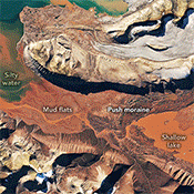
From 438 miles above earth (705 km), Landsat satellites record the spectral story of Earth’s land surfaces and near-shore coastal waters. These data—used by scientists for a huge array of applications—also provide stunning images of the planet we call home.
Explore more than 50 years of the Landsat program through animated fly-overs and line art in this graphics library.

Discover captivating videos and podcasts exploring Landsat satellites and their essential role in Earth observation. From stunning visuals to expert discussions, this collection deepens your understanding of Landsat’s vital role in monitoring our dynamic planet for over 50 years.
Copyright Information
All information, data and imagery on this website are in the public domain. Public domain images are free of copyright assertions. NASA and other public agencies that fund and run observatories do not usually assert copyright in their imagery, and therefore, permission to reproduce is not required if attributed correctly. The correct attribution for imagery obtained from this site is: “Landsat imagery courtesy of NASA Goddard Space Flight Center and U.S. Geological Survey” or “USGS/NASA Landsat” For more details, see the NASA Media Guidelines webpage.
