
Celebrating 53 Years Since Landsat 1’s Launch
When the first Landsat satellite launched in 1972, it posed the following question: could we manage our natural resources using remotely–sensed data? The answer, 53 years on, is a resounding “yes.”

One Million Reasons to Celebrate Landsat 9
The USGS Earth Resources Observation and Science Center archive has more than one million Landsat 9 Level-1 products (that’s over 1 billion megabytes of data)!

A Planet in Focus – Landsat 7’s Legacy
Celebrating the 25-year mission of Landsat 7, a NASA/USGS satellite that revolutionized Earth observation with high-resolution imagery used in agriculture, disaster response, climate research, and more.

Shifting Coastlines in the Arctic
The Arctic is changing rapidly. Recent research unveiled a new dataset of 40 years of coastlines shifting across the Arctic.

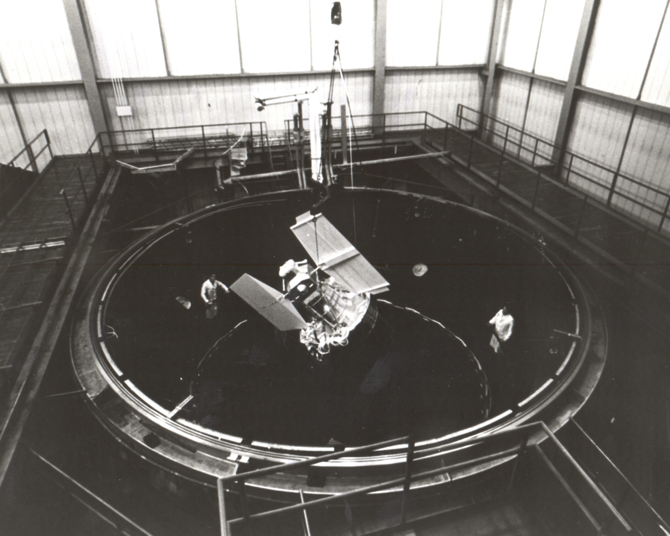
A Final Farewell to Landsat 7
The Landsat 7 satellite launched in April 1999 and will be decommissioned after 26 years in orbit. Its science mission, focused on collecting imagery data of Earth’s land and inland waters, spanned 25 years.
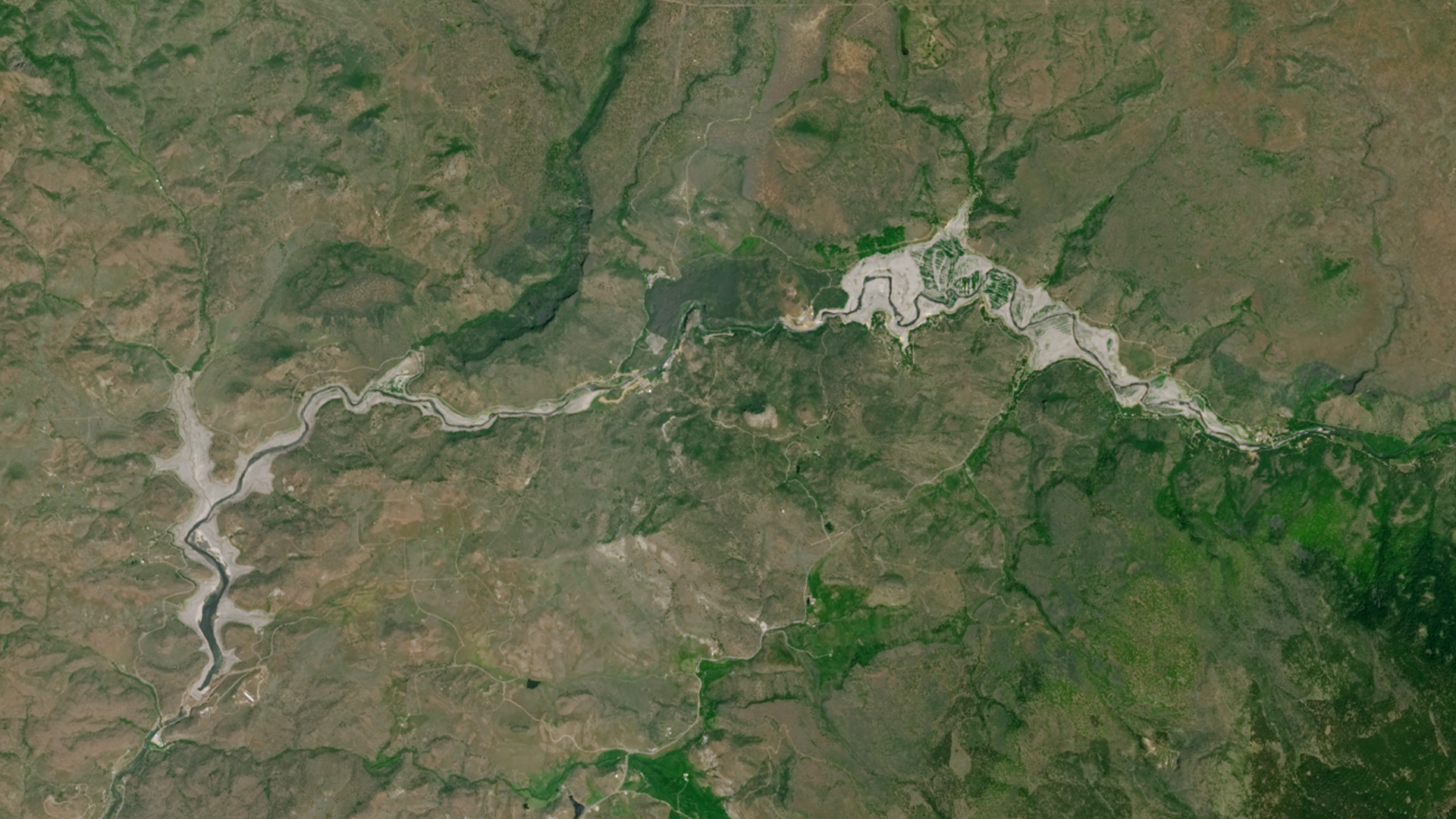
Undamming the Klamath
Between October 2023 and October 2024, the four dams of the Klamath Hydroelectric Project were taken down, opening more than 400 miles of salmon habitat.

Saudi Arabia’s Desert Agriculture
In this animation of 2024 and January 2025, crop fields in Saudi Arabia cycle through their growing seasons.

Landsat at Work: Conserving Water and Growing High Quality Grapes
Using Landsat’s thermal imagery, researchers at Gallo Winery have been able to better understand vineyard water needs and optimize irrigation.
One Million Reasons to Celebrate Landsat 9
The USGS Earth Resources Observation and Science Center archive has more than one million Landsat 9 Level-1 products (that’s over 1 billion megabytes of data)!
A Planet in Focus – Landsat 7’s Legacy
Celebrating the 25-year mission of Landsat 7, a NASA/USGS satellite that revolutionized Earth observation with high-resolution imagery used in agriculture, disaster response, climate research, and more.
Shifting Coastlines in the Arctic
The Arctic is changing rapidly. Recent research unveiled a new dataset of 40 years of coastlines shifting across the Arctic.
A Final Farewell to Landsat 7
The Landsat 7 satellite launched in April 1999 and will be decommissioned after 26 years in orbit. Its science mission, focused on collecting imagery data of Earth’s land and inland waters, spanned 25 years.
Undamming the Klamath
Between October 2023 and October 2024, the four dams of the Klamath Hydroelectric Project were taken down, opening more than 400 miles of salmon habitat.
Saudi Arabia’s Desert Agriculture
In this animation of 2024 and January 2025, crop fields in Saudi Arabia cycle through their growing seasons.
Landsat at Work: Conserving Water and Growing High Quality Grapes
Using Landsat’s thermal imagery, researchers at Gallo Winery have been able to better understand vineyard water needs and optimize irrigation.

Forty Years of Change in Louisiana’s Wetlands
Landsat images show that in the past 40 years alone, Louisiana’s coastal wetlands have undergone substantial changes.

Hispaniola’s Changing Forests
Haiti lost nearly half of its primary forests between 1996 and 2022, with fires and tree-cutting being major drivers of loss, according to a new study.
One Million Reasons to Celebrate Landsat 9
The USGS Earth Resources Observation and Science Center archive has more than one million Landsat 9 Level-1 products (that’s over 1 billion megabytes of data)!
A Planet in Focus – Landsat 7’s Legacy
Celebrating the 25-year mission of Landsat 7, a NASA/USGS satellite that revolutionized Earth observation with high-resolution imagery used in agriculture, disaster response, climate research, and more.
Shifting Coastlines in the Arctic
The Arctic is changing rapidly. Recent research unveiled a new dataset of 40 years of coastlines shifting across the Arctic.
A Final Farewell to Landsat 7
The Landsat 7 satellite launched in April 1999 and will be decommissioned after 26 years in orbit. Its science mission, focused on collecting imagery data of Earth’s land and inland waters, spanned 25 years.
Undamming the Klamath
Between October 2023 and October 2024, the four dams of the Klamath Hydroelectric Project were taken down, opening more than 400 miles of salmon habitat.
Saudi Arabia’s Desert Agriculture
In this animation of 2024 and January 2025, crop fields in Saudi Arabia cycle through their growing seasons.
Landsat at Work: Conserving Water and Growing High Quality Grapes
Using Landsat’s thermal imagery, researchers at Gallo Winery have been able to better understand vineyard water needs and optimize irrigation.
Forty Years of Change in Louisiana’s Wetlands
Landsat images show that in the past 40 years alone, Louisiana’s coastal wetlands have undergone substantial changes.
Hispaniola’s Changing Forests
Haiti lost nearly half of its primary forests between 1996 and 2022, with fires and tree-cutting being major drivers of loss, according to a new study.
