
Landsat Helps Identify South America's Largest Meteor Impact Crater
Argentinian geologist, Max Rocca, used Landsat data to find an massive impact crater in Columbia. By viewing large online mosaics of Landsat data available from Stennis Space Flight Center, Rocca noticed
President's FY 2011 Budget for USGS Includes LDCM Funding
Source: USGS In a fiscally responsible budget that emphasizes cost containment, management efficiencies and program savings, the President’s proposed $1.1 billion budget for the U.S. Geological Survey (USGS) in fiscal year
Calibration Update To ETM+ Thermal Band
Source: USGS Effective January 1, 2010, the calibration of the ETM+ thermal band was modified to correct for a lifetime gain error detected by the vicarious calibration teams. Changes were made
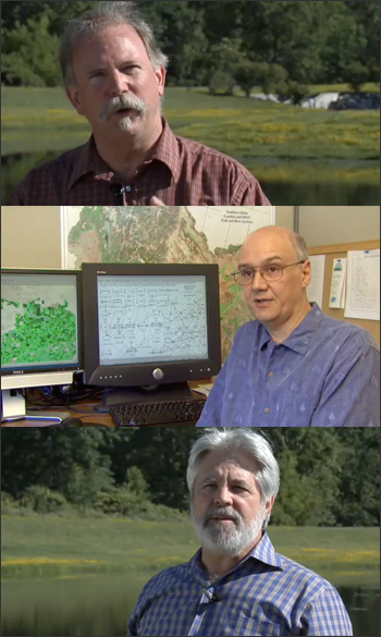
Water Watchers
Landsat doesn’t measure water vapor directly, but evaporating and transpiring water takes energy, something Landsat does observe. If they knew how much energy was going into driving evapotranspiration, Morse and Allen could estimate how much water a particular field of crops had consumed on any particular day.
Ecosystem, Vegetation Affect Intensity of Urban Heat Island Effect
NASA researchers studying urban landscapes have found that the intensity of the “heat island” created by a city depends on the ecosystem it replaced and on the regional climate. Urban
GEO Announces New Annual Assessments of Forest Carbon
Source: Group on Earth Observations “The only way to measure forests efficiently is from space,” Group on Earth Observations (GEO) director, José Achache said referring to the group’s goal to make
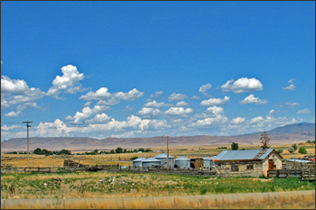
Landsat Cultivates Fans Among Midwest Farmers
Contributor: Gretchen Cook-Anderson, NASA Earth Science News Team Noreen Thomas’ farm looks like a patchwork quilt. Fields change hue with the season and with the alternating plots of organic wheat, soybeans,
Landsat-Based Water-Use Mapping Method Hailed as an Important American Government Innovation
In the dry Western states, where irrigated agriculture accounts for 86% of all water consumption, the water-use (evapotranspiration or ET) information provided by METRIC is critical for arbitrating increasingly common water-resource conflicts.
Fire Prevention in Spain
Science brief summary by: Laura E. P. Rocchio A group of European researchers have used Landsat data collected over a quarter of a century to evaluate fire management methods in
NASA Selects Launch Services Provider for Earth Imagery Satellite
NASA’s Launch Services Program office at the Kennedy Space Center, Fla., has selected Lockheed Martin Commercial Launch Services of Littleton, Colo., for launching of the Landsat Data Continuity Mission. The
Greeks Get Space-Based Help In Wake of Deadly Fires
Contributor: European Space Agency (ESA) Cleanup and rebuilding teams responding to the devastation across Greece caused by this summer’s deadly fires are getting help from space. A series of crisis
Landsat Helps Rain Forest Protection Work in Peru
Contributor: Gregory Asner A new regional study shows that land-use policies in Peru have been key to tempering rain forest degradation and destruction in that country. Scientists at the Carnegie Institution’s
Landsat Links Urban Growth and Rainfall Pattern Change
For the first time, scientists have used satellite images to demonstrate a link between rapid city growth and rainfall patterns, as well as to assess compliance with an international treaty
A LEGO Landsat
Did you know LEGO sells model kits that enable you to build replicas of the Landsat 5 and Landsat 7 satellites? Well, thanks to Tom Hill of the Landsat project,
NASA Awards Contract for LDCM Instrument
NASA has selected Ball Aerospace and Technologies Corp. of Boulder, Colo., to develop the Operational Land Imager instrument for the Landsat Data Continuity Mission (LDCM). The instrument will capture images
NASA Awards LDCM Accommodation Study
NASA Goddard Space Flight Center’s Rapid Spacecraft Development Office (RSDO) awarded delivery orders to four contractors for the Landsat Data Continuity Mission (LDCM) Spacecraft Accommodation Study on April 30. “The
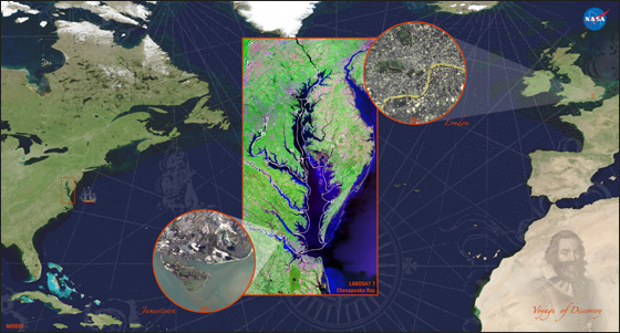
Landsat Image Presented to Queen Elizabeth II
In a historical event for NASA’s Goddard Space Flight Center, Queen Elizabeth II of England visited the NASA campus on May 8, 2007. One of the many diplomatic gifts presented to the Queen was a poster commemorating John Smith’s voyage of discovery in 1607 using data from Landsat 7, MODIS, and EO-1.
Fire Prevention in Spain
Science brief summary by: Laura E. P. Rocchio A group of European researchers have used Landsat data collected over a quarter of a century to evaluate fire management methods in
NASA Selects Launch Services Provider for Earth Imagery Satellite
NASA’s Launch Services Program office at the Kennedy Space Center, Fla., has selected Lockheed Martin Commercial Launch Services of Littleton, Colo., for launching of the Landsat Data Continuity Mission. The
Greeks Get Space-Based Help In Wake of Deadly Fires
Contributor: European Space Agency (ESA) Cleanup and rebuilding teams responding to the devastation across Greece caused by this summer’s deadly fires are getting help from space. A series of crisis
Landsat Helps Rain Forest Protection Work in Peru
Contributor: Gregory Asner A new regional study shows that land-use policies in Peru have been key to tempering rain forest degradation and destruction in that country. Scientists at the Carnegie Institution’s
Landsat Links Urban Growth and Rainfall Pattern Change
For the first time, scientists have used satellite images to demonstrate a link between rapid city growth and rainfall patterns, as well as to assess compliance with an international treaty
A LEGO Landsat
Did you know LEGO sells model kits that enable you to build replicas of the Landsat 5 and Landsat 7 satellites? Well, thanks to Tom Hill of the Landsat project,
NASA Awards Contract for LDCM Instrument
NASA has selected Ball Aerospace and Technologies Corp. of Boulder, Colo., to develop the Operational Land Imager instrument for the Landsat Data Continuity Mission (LDCM). The instrument will capture images
NASA Awards LDCM Accommodation Study
NASA Goddard Space Flight Center’s Rapid Spacecraft Development Office (RSDO) awarded delivery orders to four contractors for the Landsat Data Continuity Mission (LDCM) Spacecraft Accommodation Study on April 30. “The
Landsat Image Presented to Queen Elizabeth II
In a historical event for NASA’s Goddard Space Flight Center, Queen Elizabeth II of England visited the NASA campus on May 8, 2007. One of the many diplomatic gifts presented to the Queen was a poster commemorating John Smith’s voyage of discovery in 1607 using data from Landsat 7, MODIS, and EO-1.
