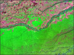
- Argentinian geologist, Max Rocca, used Landsat data to find an massive impact crater in Columbia. By viewing large online mosaics of Landsat data available from Stennis Space Flight Center, Rocca noticed a curious semi-circular curve of the Vichada River as it made its way to the Orinoco River.
With further analysis, Rocca discovered a 20-km circular depression surrounded by a 30-km ring of low hills and a 50-km ring of outer hills—an impact crater hallmark. Rocca presented his findings at a 2004 meeting of the Meteoritical Society in Rio de Janeiro, but without ground validation, he could only stay it was a possible/likely impact crater. Rocca considered traveling to the Columbian site, but politically dangerous conditions there thwarted that plan. Fortunately, geologists headed by Orlando Hernandez from Columbia’s National University in Bogota and Ralph von Frese from Ohio State University decided to conduct a gravitational anomaly study of the region. Their results indicated a telltale “sombrero anomaly” associated with impact craters. Their findings validated the discovery of South American’s largest impact crater and were published in the Dec. 2009 Earth Sciences Research Journal.
Further Reading:
+ Saving Earth One Asteroid At A Time, Space Daily [external link]
+ Planetary Society Researcher Max Rocca Discovers Largest Impact Crater in South America, The Planetary Society [external link]


