News Archives

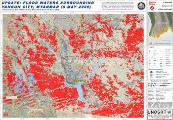
NASA Data Helps Pinpoint Impacted Populations in Disaster Aftermath
Contact: Gretchen Cook-Anderson, NASA/GSFC When two catastrophic natural disasters struck within days of each other in May 2008, disaster relief, humanitarian aid, and health officials, as well as members of the
Landsat Data Continuity Mission USGS Acquisition Strategy for Ground System Segments
The National Aeronautics and Space Administration (NASA) and the Department of the Interior’s U.S. Geological Survey (USGS) share responsibility for the Landsat Data Continuity Mission (LDCM). NASA will develop the
NASA Selects Contractor for Landsat Data Continuity Mission Spacecraft
Contact: Cynthia O’Carroll, NASA/GSFC NASA has selected General Dynamics Advanced Information Systems, Inc., to build the Landsat Data Continuity Mission (LDCM) spacecraft. Under the terms of the $116,306,179 delivery order, General
Landsat’s Role in Chesapeake Bay Management
• John Smith’s Bay Then & Now – When Captain John Smith first explored the Chesapeake Bay in 1607, the “Great Shellfish Bay,” as it was called by the Algonquian
Landsat Tracks Down A Pesky Weed in Australia
Source: Minister for Primary Industries and Fisheries, Australia Queensland scientists are using satellite technology to help manage one of Australia’s most damaging weeds. “This a world first,’’ Minister for Primary
Fire Prevention in Spain
Science brief summary by: Laura E. P. Rocchio A group of European researchers have used Landsat data collected over a quarter of a century to evaluate fire management methods in
NASA Selects Launch Services Provider for Earth Imagery Satellite
NASA’s Launch Services Program office at the Kennedy Space Center, Fla., has selected Lockheed Martin Commercial Launch Services of Littleton, Colo., for launching of the Landsat Data Continuity Mission. The
Greeks Get Space-Based Help In Wake of Deadly Fires
Contributor: European Space Agency (ESA) Cleanup and rebuilding teams responding to the devastation across Greece caused by this summer’s deadly fires are getting help from space. A series of crisis
News Archives
NASA's GeoCover 2000 Landsat Product Promotes Geo-commerce Globally
In 2000, NASA sponsored the creation of an orthorectified Landsat 7 mosaic of all of Earth’s landmasses (with the exception of Antarctica) as part of the GeoCover 2000 project. This
USGS Landsat Archive reaches 2,000,000 scenes
From The Landsat Project Update (a USGS publication): “The Landsat archive at USGS EROS is a continuous record that stores data from the very first Landsat mission up to the
Landsat Data Used to Understand Urban Environments
A new website featuring Landsat images of 77 international cities has been published by the Socioeconomic Data and Applications Center (SEDAC). By analyzing urban reflectance (both visible and infrared) and
Landsat Helps Monitor Toxic Algal Blooms in New Zealand
Every summer in New Zealand, recreational swimming in Okawa Bay is often prohibited because of toxic algal blooms. According to a Jan. 20 article in the New Zealand Herald, Waikato University
Landsat Data Part of MSN® Virtual Earth™
MSN® Virtual Earth™ is a web map server that offers search and mapping capabilities. As described in a July 2005 Microsoft press release, “the service enables users to search, discover,
LDCM Instrument Request for Proposals Released
The LDCM Operational Land Imager (OLI) Request For Proposals (RFP) has been posted to the NASA Acquisition Internet Service website. The following documents that are referenced in the OLI RFP are
As Population Grows, So Do Urban Areas
Source: USGS News Release Contact: Jonathan H. Smith, 703 648-4516 USGS Release : December 27, 2006 A new USGS publication – Rate, Trends, Causes, and Consequences of Urban Land-Use Change in the United
USGS Announces TerraLook
Source: USGS News Release Contact: Gene Fosnight, 605-594-605 The U.S. Geological Survey (USGS) Center for Earth Resources Observation and Science (EROS), in cooperation with the National Aeronautics and Space Administration (NASA),
GLOBE Star for Landsat Outreach Effort
The Global Learning and Observations to Benefit the Environment (GLOBE) effort is an international science education program for primary and secondary schools that focuses on hand-on learning. In late September