
Satellites orbiting the Earth often fly over other flying things. The motion of things like airplanes together with their altitude above the ground (which the satellite imagery is corrected to) can cause some interesting visual artifacts.
Landsat 8 uses “push broom” sensors meaning an image is created as a long row of sequential detectors collect light reflected from Earth as the satellite flies over head.
For the Operational Land Imager aboard Landsat 8, its detectors are stacked in this order: panchromatic, blue, coastal/aerosol, NIR, red, green, SWIR2, SWIR1, cirrus. So when Landsat 8 flies over a plane, each spectral band (i.e the measurement of energy made by each detector array) is slightly offset since they are acquiring their respective images at slightly different times (fractions of a second).
For instance, in a pan-sharpened Landsat 8 image, you often see a plane as a bright dot, with a few fainter dots ahead of it on its trajectory. This phenomenon is responsible for those rainbow-colored planes you see in Google Maps when looking at images collected from high-resolution push broom sensors.
When Landsat 8 flies over a satellite in a lower orbit, you get a greater offset band-to-band because of the much faster motion of the satellite and its higher elevation above the surface of earth.
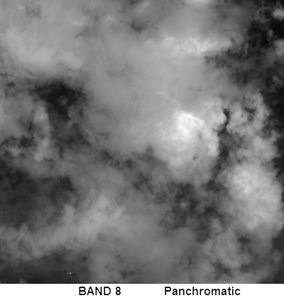
On Sunday, Rochester Institute of Technology scientist, Mike Gartley, noticed that Landsat 8 had gotten a good look at the International Space Station as it flew over India. Landsat 8 orbits at ~705 km (438 miles). The International Space Station orbits around 400 km (248 miles) at a nominal speed of ~7.7 km/second (17,100 mph). Mike created the animated sequence above showing the location of the International Space Station in each of the Landsat 8 OLI bands—giving us a glimpse of the station as it flies by below.
Here are some details about this image:
product ID: LC81410462016171LGN00
date/time: 06/19/2016 (fractional day = 171.2016)
WRS row/path: 141 / 046
B8 lat/lon of ISS: 19.361903N, 84.161581E
ISS vel (obj space): -0.0105 rad/s cross track, 0.0458 rad/s along-track
Addendum June 24, 2016:
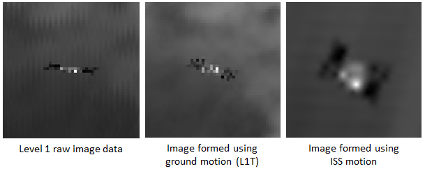
For the animation above, Mike used L1T Landsat 8 data, meaning the data had been registered to the ground. For the image sequence below, Mike used raw Landsat data to (1) process the image to the ground (using ground motion) and then (2) process the data using the International Space Station motion, check out the difference and Mike’s explanation:
Since the International Space Station is moving through Landsat’s field of view much faster than the ground and at a different angle, it appears spatially distorted in the normally disseminated L1T image product (middle image). However, an image may be formed from the Level 1 Raw sensor data (left image) using the known motion of the International Space Station, instead of the ground, as it moves through Landsat’s field of view. If one does this, the resulting image has ground level features with significant spatial distortion but results in a well formed image of the Space Station.
*Note: Last year Mike brought to our attention that Landsat 8 images its predecessor, the now decommissioned Landsat 5.


