Source: The Landsat Tutorial Workbook

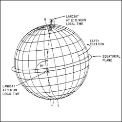
This schematic appears in The Landsat Tutorial Workbook: Basics of Satellite Remote Sensing, written by Dr. Nicholas Short and published by the NASA Scientific and Technical Information Branch in 1982.
Dr. Short writes, “The Landsat-1 spacecraft was launched on July 23, 1972, and positioned in the orbit shown in [this figure]. Landsat-2 was launched on June 22, 1975, and Landsat-3 was launched on March 5, 1978.
“These satellites [had] a nominal altitude of 917 km (570 miles); 99° orbital inclination, which makes them nearly polar; and a sun-synchronous orbit, which means that the orbit plane precesses about the Earth at the same angular rate that the Earth moves about the Sun. This feature enables the spacecraft to cross the Equator at the same local time (about 9:30 to 10:00 a.m.) on the sunlit side of the Earth.”

