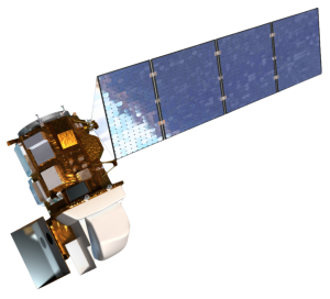
Excepted from source: Vicki Cox, Northrop Grumman

Representatives from NASA and Northrop Grumman successfully completed a rigorous Critical Design Review (CDR) demonstrating that the program meets all technical performance measures and requirements. The execution of the design review enables the program to effectively transition into manufacturing and prepare for the assembly, test and launch operations phase of the mission. The Landsat 9 spacecraft will be manufactured and tested at the company’s Gilbert, Arizona, facility and is currently planned for launch in late 2020. The spacecraft will be operated by the U.S. Geological Survey once in orbit.
“I am extremely pleased with the progress our team has made since the contract was awarded about a year and a half ago. We have passed every milestone and remain on schedule to launch in 2020,” said Steve Krein, Vice President of Science and Environmental Programs at Northrop Grumman. “This will be the fourth Landsat satellite built by Northrop Grumman for NASA and demonstrates our continued ability to deliver high-quality land imaging satellites that support the Landsat program’s long record of success.”
The Critical Design Review took place February 26 through March 1 at Northrop Grumman’s facility in Gilbert, Arizona. Landsat 9 will extend the length of the overall Landsat series to half a century, providing the longest continuous record of the Earth’s surface as seen from space. Northrop Grumman has built three other Landsat satellites, including Landsat 8, which was launched in 2013, and is providing high quality images in quantities that surpass mission requirements. The company was also responsible for the successful Landsat 4 and Landsat 5 satellites launched in 1982 and 1984 [Editor’s note: Landsat 4 and 5 satellites were built by GE Space Systems Division, based on a Multimission Modular Spacecraft design originally developed by Orbital-aquired Fairchild Space and Defense.]
Landsat 9 is based on Northrop Grumman’s flight-proven LEOStar-3™ spacecraft bus platform, the same that was successfully used on Landsat 8. The Ice, Cloud and Land Elevation satellite (ICESat-2) and the Joint Polar Satellite System (JPSS-2) spacecraft are also based on the LEOStar-3 bus platform and currently in production for NASA at Northrop Grumman’s Gilbert facility.

Be Part of What’s Next: Emerging Applications of Landsat at AGU24
Anyone making innovative use of Landsat data to meet societal needs today and during coming decades is encouraged to submit and abstract for the upcoming “Emerging Science Applications of Landsat” session at AGU24.


