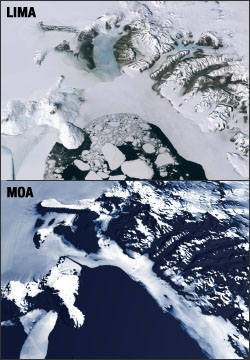
Source: NASA SVS

The Landsat Image Mosaic of Antarctica (LIMA) is a data product jointly produced by the U.S. Geological Survey (USGS), the British Antarctic Survey (BAS), the National Aeronautics and Space Administration (NASA), and funded by the National Science Foundation (NSF). LIMA images featured on the NASA Science Visualization Studio (SVS) website are compared to what is currently the best mosaic of Antarctica called the MODIS mosaic Of Antarctica (MOA). MOA is a composite of 260 swaths comprised of both Terra and Aqua MODIS images acquired between November 20, 2003 and February 29, 2004. MOA’s data resolution is approximately 150 meters per pixel.
From large continental views of Antarctica, MOA is more than adequate. However, as we get closer in to the surface, the resolution of the MOA data begins to show, thus highlighting the value of the LIMA product once it is complete.
The LIMA data shown on the SVS website uses the pan-chromatic band which translates to a resolution of 15 meters per pixel (opposed to MOA’s 150 meters per pixel resolution). The 13 swaths used to generate this sample mosaic where acquired between December 25, 1999 and December 31, 2001. The elevation shown is actual (1x). Comparing this sample LIMA dataset alongside MOA data over the same region shows the value of having a higher resolution view of Antarctica.

Be Part of What’s Next: Emerging Applications of Landsat at AGU24
Anyone making innovative use of Landsat data to meet societal needs today and during coming decades is encouraged to submit and abstract for the upcoming “Emerging Science Applications of Landsat” session at AGU24.


