
From Seeds to Satellites
NASA is partnering with farmers to deliver new technology, new tools and new data to help producers make decisions at every level, from the farm field to the state to the nation to the world.

NASA is partnering with farmers to deliver new technology, new tools and new data to help producers make decisions at every level, from the farm field to the state to the nation to the world.
In 1980, artist Tom Van Sant created the world’s largest manmade image with the help of Landsat 3.
In May of 1972, two months before the launch of Landsat 1, engineers from Hughes Aircraft Company took their engineering model of the Multispectal Scanning System (MSS) out to Yosemite National Park, set it up on Glacier Point, and took this test image of Half Dome from a 2.5 miles away. The image composite shown above uses the MSS bands 3, 2, and 1.
Eight months ago, on June 5, 2013, the U.S. Geological Survey decommissioned the venerable Landsat 5 satellite. That day, the USGS Landsat Flight Operations Team transmitted the last command to Landsat 5, effectively terminating the mission and leaving it in a disposal orbit.
Building a satellite is a major collaboration and involves the hard work of many different types of engineers. The engineering process for Landsat involves defining
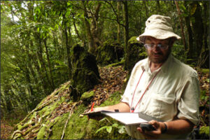
After using Landsat data to determine the forest extent, Bayliss and his colleagues at the Royal Botanical Gardens Kew decided an expedition was in order. In October and November of 2008, 28 scientists visited Mount Mabu and discovered a cornucopia of wildlife there including three new species of butterflies and a new snake species.
Did you know LEGO sells model kits that enable you to build replicas of the Landsat 5 and Landsat 7 satellites?
MSN® Virtual Earth™ is a web map server that offers search and mapping capabilities. As described in a July 2005 Microsoft press release, “the service
When Google Earth first was released, a huge part of the planet was shown using pan-sharpened Landsat 7 ETM+ data.
Off the northeastern coast of Labrador, in the northern most reaches of the Newfoundland & Labrador province lies Landsat Island, an icy isle inhabited only by polar bears. How did such a place get named after a satellite?
