
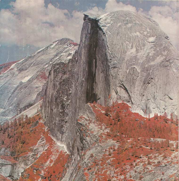
In May of 1972, two months before the launch of Landsat 1, engineers from Hughes Aircraft Company took their engineering model of the Multispectal Scanning System (MSS) out to Yosemite National Park, set it up on Glacier Point, and took this test image of Half Dome from a 2.5 miles away. The image composite shown above uses the MSS bands 3, 2, and 1. (Why are the trees red?)
The MSS was considered an experimental sensor, but it proved to be Landsat 1’s best instrument and it went on to influence the design of many future spaceborne sensors.
Excerpted from the upcoming Landsat Legacy book:
The Remarkable Multispectral Scanner
The second instrument onboard Landsat 1, the Multispectral Scanner System (MSS) built by Hughes Aircraft Company, was an experimental payload originating from an unsolicited proposal and using a less familiar “scanning” technology to acquire images.
As the then-Landsat 1 Ground System Manager Luis Gonzales explained, no one knew if the spaceborne MSS would successfully produce a digital image. As the first civilian scanner to orbit Earth, could the MSS, traveling at such a high velocity, write out its binary data in real-time? Its scan mirror whirred back and forth at the then amazing rate of 13 times per second (13.62 Hz frequency with imaging occurring only in the forward scan direction), creating a loud buzz that made an impression on every engineer and scientist who visited Hughes during the MSS fabrication. John DeNoyer, the USGS liaison to NASA for Earth-Observation Satellites at the time, compared the scanner noise to that of a hammer mill. Hughes staff assured the visitors that no one would hear it in space.
Reviewing the original MSS proposal, NASA geologist Paul Lowman thought, “this crazy thing vibrates 16 [sic] cycles a second; the moving parts will never work.” NASA engineers, USGS scientists, and many others involved with the project where naturally surprised when they saw the excellent quality of the data after launch. Virginia Norwood and her team at Hughes who built the MSS, however, were not surprised. Having seen the space-acquired MSS imagery, Lowman conceded, “I was dead wrong.”


