
From Seeds to Satellites
NASA is partnering with farmers to deliver new technology, new tools and new data to help producers make decisions at every level, from the farm field to the state to the nation to the world.

NASA is partnering with farmers to deliver new technology, new tools and new data to help producers make decisions at every level, from the farm field to the state to the nation to the world.
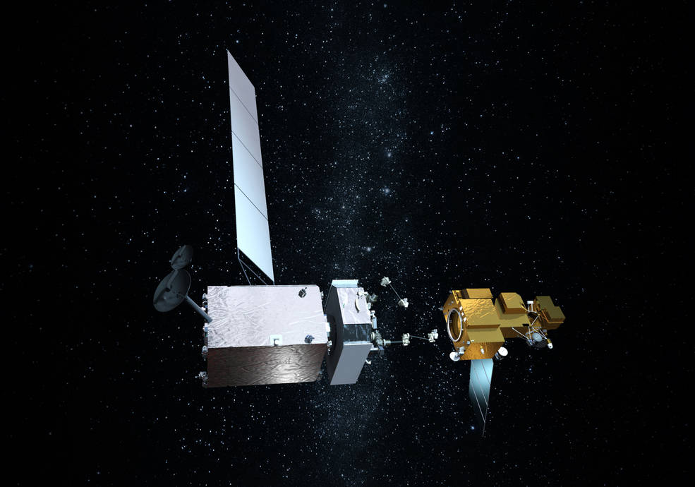
Northrop Grumman recently signed agreements to license three technologies from NASA related to satellite servicing.
In 1980, artist Tom Van Sant created the world’s largest manmade image with the help of Landsat 3.
In May of 1972, two months before the launch of Landsat 1, engineers from Hughes Aircraft Company took their engineering model of the Multispectal Scanning System (MSS) out to Yosemite National Park, set it up on Glacier Point, and took this test image of Half Dome from a 2.5 miles away. The image composite shown above uses the MSS bands 3, 2, and 1.
Eight months ago, on June 5, 2013, the U.S. Geological Survey decommissioned the venerable Landsat 5 satellite. That day, the USGS Landsat Flight Operations Team transmitted the last command to Landsat 5, effectively terminating the mission and leaving it in a disposal orbit.
Building a satellite is a major collaboration and involves the hard work of many different types of engineers. The engineering process for Landsat involves defining
The MSS data collection is among the 245 international documentary collections that make up the Memory of the World Register.
In June 2009, NASA and the U.S. Geological Survey put the finishing touches on a new collection of mapped images covering the entire land surface
Back in 2002, NASA created a film using satellite data that took viewers on a tour of Earth’s frozen regions. This year, NASA visualizers are
132,969 … 132,970 … 132,971. Like a trusty watch counting up the minutes, the Landsat 5 satellite keeps on ticking, orbit after orbit around the
UCLA geographers say they have a good idea of where Osama Bin Laden was at the end of 2001 — and perhaps where he has
In 2005, conservation scientist Dr. Julian Bayliss was looking at Landsat images of northern Mozambique with Google Earth. He was in search of regions close to
The U.S. Geological Survey has made it possible for you to retrace the historic journey of Lewis and Clark with a series of Landsat posters
Contributor: Laura E.P. Rocchio What could Landsat, potholes, and climate change have in common? Well—when you use the term “potholes” to refer to the glacially-formed
Contributor: Laura E.P. Rocchio When you think of Landsat, images of the Earth’s land surface rightly come to mind because that is the type of
Satellite imagery obtained from NASA will help archeologist Bill Middleton peer into the ancient Mexican past. In a novel archeological application, multi- and hyperspectral data
Did you know LEGO sells model kits that enable you to build replicas of the Landsat 5 and Landsat 7 satellites? Well, thanks to Tom
Researchers from Duke University’s Nicholas School of the Environment and the University of British Columbia’s Fisheries Center are using high- and mid-resolution remote sensing data
Recently a landform called a chevron was noted on a Landsat 7 image of Madagascar. These chevrons may have been formed by a mega-tsunami produced
MSN® Virtual Earth™ is a web map server that offers search and mapping capabilities. As described in a July 2005 Microsoft press release, “the service
Google™ once again wowed web users worldwide with its release of Google Earth™ (external link). This product allows users to have a bird’s-eye view of almost any place
Off the northeastern coast of Labrador, in the northern most reaches of the Newfoundland & Labrador province lies Landsat Island, an icy isle inhabited only
