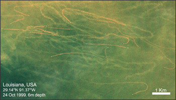
Researchers from Duke University’s Nicholas School of the Environment and the University of British Columbia’s Fisheries Center are using high- and mid-resolution remote sensing data to better understand the global impact of the fishing industry’s trawling practices. The large plumes of sediment, or “mudtrails” produced by trawlers as they dredge the sea bottom are discernable from space. Among marine fishery catch methods, trawling is considered especially unsustainable. Trawling disturbs (and often destroys) the natural sea floor ecosystem; additionally, surviving benthic organisms can be smothered as the suspended sediments of the trawler mudtrails resettle.
Using federal mid-resolution (15–30 m) Landsat and ASTER data, along with commercial high-resolution (1–3 m) QuickBird data from Google Earth, Van Houtan (Duke) and Pauly (UBC) aim to better quantify the indirect impacts of trawling in hopes of establishing more sustainable fisheries in the future.
For more information:
- Van Houtan/Pauly research website, Duke University (external link)
- Earth Observatory Image of the Day


