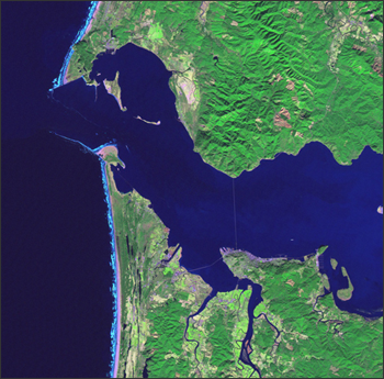
The U.S. Geological Survey has made it possible for you to retrace the historic journey of Lewis and Clark with a series of Landsat posters that feature significant stops and encampments along their route, from Wood River Camp to Cape Disappointment.
From the USGS Website:
To commemorate the 200th anniversary of the Lewis and Clark Corps of Discovery expedition from 1803-1806 and the 125th anniversary of the United States Geological Survey (USGS), the USGS National Center for Earth Resources Observation and Science (EROS) has assembled a collection of satellite images that provides a contemporary view the route that Lewis and Clark took from St. Louis, Missouri, to the Pacific Coast.
The topographic relief map of the conterminous United States provides geographic context by showing the expedition’s entire route. The map was created by processing digital elevation model (DEM) data from The National Map. Differences in elevation on the map are shown in a range of colors, from dark green for low elevations to white for high elevations. The map conveys a sense of the vast and increasingly rugged terrain Lewis and Clark encountered on their journey.
The twenty-two individual images in the collection are satellite scenes that provide a modern view of historically significant stops along the expedition route. These detailed images were acquired during 2001-2002 by the Enhanced Thematic Mapper-plus (ETM+) sensor carried aboard the Earth-orbiting satellite, Landsat 7. The sensor records waves of light energy reflected from the Earth’s surface. In these images, healthy vegetation appears in shades of green. Rivers, lakes, and streams are various shades of blue. Bare soil and geologic rock formations range from tan to brown.
Modern scientific data-gathering instruments, such as satellite sensors, are far more sophisticated than any tool used by members of the Lewis and Clark expedition. But the spirit of dedication and sense of discovery they demonstrated during the journey live on in their contemporary counterparts. USGS scientists use satellite images and many other types of data to learn more about changes taking place throughout America and worldwide. In mission and in spirit, the USGS continues what Lewis and Clark began.
The images in this collection were taken from the extensive satellite image archives at the USGS EROS Data Center near Sioux Falls, South Dakota.
+ Visit the USGS Lewis and Clark feature

Be Part of What’s Next: Emerging Applications of Landsat at AGU24
Anyone making innovative use of Landsat data to meet societal needs today and during coming decades is encouraged to submit and abstract for the upcoming “Emerging Science Applications of Landsat” session at AGU24.


