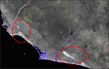
Recently a landform called a chevron was noted on a Landsat 7 image of Madagascar. These chevrons may have been formed by a mega-tsunami produced 4,800 years ago by a meteorite or comet impact with the Indian Ocean.
Tsunami-generated chevrons rarely consist of a single feature but are nested like the stripes on a military uniform. The Ampalaza chevron field on the left consists of the overall v-shaped deposit and smaller nested chevrons, each with up to 20 m of relief. The axes of the chevrons indicate the direction of flow, in this case from the southeast. The tsunami flowed across 40 km of land surface at an estimated depth of 90 m. The Fenambosy chevron field on the right has lost its overall v-shape because the water’s flow was spilt landward over an escarpment 200 m above sea level. Wind has reshaped the individual chevrons more than at Ampalaza. Both chevron fields were formed within the last 10,000 years, most likely around 2,800 BC. Seaward of the main Fenambosy chevron field, note the irregularly spaced chevrons, which may represent an older event. The Madagascar chevrons are far from unique, as similar landforms have been identified on the coastlines of all major oceans.
Contributor: USGS (The Landsat Project Update)
For more information:
- Dallas Abbott, Lamont-Doherty Earth Observatory
- Bruce Masse, Los Alamos National Laboratory
- Viacheslav Gusiakov, Russian Academy of Science
- “Ancient Crash, Epic Waves” – The New York Times, Science section, Nov. 14, 2006 (external link)


