MSS You! Photos from a 1972 Road Trip
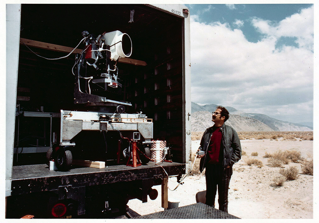
Two months before the launch of Landsat 1, the engineering model of the satellite’s multispectral scanner system went on a California road trip.

Two months before the launch of Landsat 1, the engineering model of the satellite’s multispectral scanner system went on a California road trip.

Thomas managed the development of early Landsat image processing software systems and became the resident expert on the Computer Compatible Tapes that were used to store early Landsat imagery.
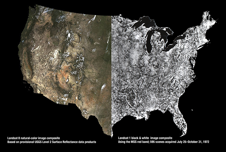
USGS released provisional Landsat surface reflectance products in December. Surface reflectance products correct for atmospheric distortions thereby providing “less hazy” images.
Whether it’s cranberry relish, cranberry fluff, cranberry sauce, cranberry salad, or cranberry salsa you’ll be enjoying today, it’s fun to see where cranberries grow. A series of commercial cranberry beds can be seen on this Oct. 6, 1999 Landsat 7 image.
Since 2008, all Landsat data—archived and newly acquired—have been available for free download. On September 16, 2014, users worldwide downloaded over 14,000 scenes from the servers at the USGS Earth Resources Observation and Science (EROS) Center. These downloads brought the total number of Landsat data downloads to more than 20 million.
This Landsat (MSS) image, acquired by Landsat 2 on May 27, 1981 (WRS-1 Path 186 Row 26), marks the one-millionth MSS image acquired by the Landsat satellites. The image covers a 115×115-mile (185×185-km) area of the steppe (vast treeless plain) region of southwestern Russia. The large body of water on the south-central portion of the image is the Tsimlyanskoye reservoir, located approximately 60 miles (96 km) west of Volgograd (formerly Stalingrad) and 550 miles (885 km) south of Moscow.
In 1980, artist Tom Van Sant created the world’s largest manmade image with the help of Landsat 3.
On public land in the Ivanpah Valley near the California/Nevada border, the world’s largest concentrated solar thermal plant sprawls across the desert landscape. Just on the other side of Interstate 15 (the long straight diagonal line) is the location of a Landsat calibration site.
To continually map the Earth’s surface using Landsat data, an entirely new projection had to be created. This new projection was created by John Parr Snyder and is known as the Space Oblique Mercator (SOM) projection. It is considered, “one of the most complex projections ever devised” according to cartographic historian, John W. Hessler.
This 1977 NASA video series, “Landsat—Satellite for All Seasons,” provides examples of early Landsat applications.
The Landsat program is the longest continuous global record of Earth observations from space—ever. On July 23, 1972 NASA launched the first satellite in this program, then known as ERTS, the Earth Resources Technology Satellite and later renamed Landsat 1. In 2012, for the 40th birthday of Landsat, NASA edited together selections of an archive video from 1973 about the ERTS launch. Featured in this 1973 video was a senior geologist at NASA, Nicholas Short, and at Dartmouth College, Robert Simpson and David Lindgren. NASA and the U.S. Department of the Interior through the U.S. Geological Survey (USGS) jointly manage Landsat, and the USGS preserves a more than 40-year archive of Landsat images that is freely available over the Internet.
In May of 1972, two months before the launch of Landsat 1, engineers from Hughes Aircraft Company took their engineering model of the Multispectal Scanning System (MSS) out to Yosemite National Park, set it up on Glacier Point, and took this test image of Half Dome from a 2.5 miles away. The image composite shown above uses the MSS bands 3, 2, and 1.
