Search
Close this search box.

A Face Behind Landsat Images: Meet Dr. Valerie L. Thomas

A Face Behind Landsat Images: Meet Dr. Valerie L. Thomas

Interview conducted by Laura E.P. Rocchio, NASA Landsat Communications and Public Outreach team

Valerie Thomas with CCTs
Valerie Thomas in 1979 standing with a stack of early Landsat Computer Compatible Tapes (CCTs). Thomas was responsible for the development of early Landsat digital media formatting.

In Landsat’s long history many talented people were brought together to make the vision of Earth observation from space a reality.

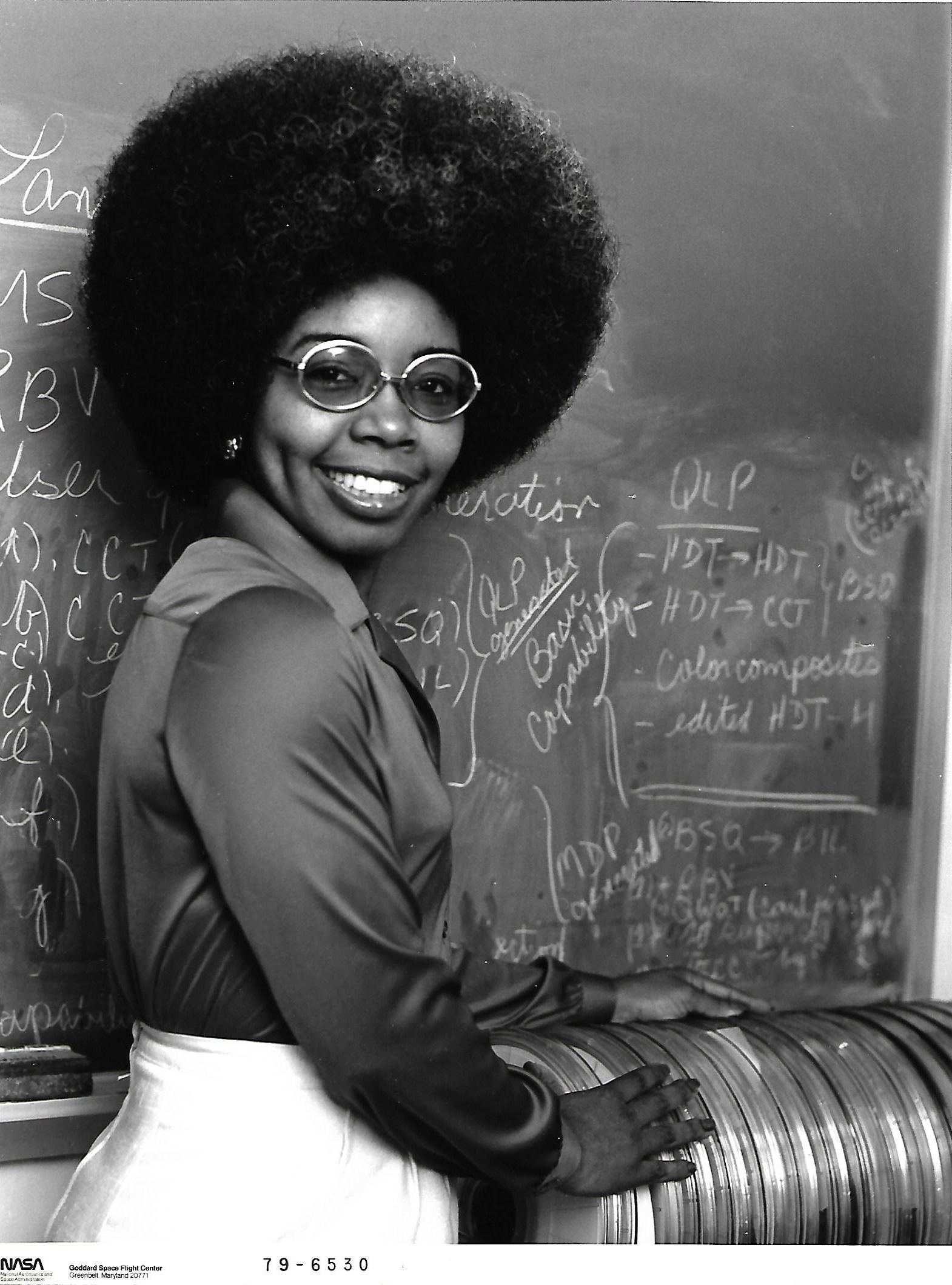
One of those people was Dr. Valerie L. Thomas. Thomas was an integral part of the early Landsat digital image processing team.

Working at NASA’s Goddard Space Flight Center, she managed the development of early Landsat image processing software systems and became the resident expert on the Computer Compatible Tapes, or CCTs, that were used to store early Landsat imagery.

Thomas was one of the image processing specialists who facilitated the ambitious Large Area Crop Inventory Experiment, known as LACIE—a project that showed for the first time that global crop monitoring could be done with Landsat satellite imagery.

We recently had an opportunity to talk with Thomas about her work during the nascent Landsat program.

This is what she shared:

What was the path (education and career-wise) that led you to the Landsat Program?
In college, I majored in physics with almost a double major in math. When I started work at NASA, I had not seen a computer except in science fiction movies. Since my job involved writing computer programs, I decided to learn as much as possible about computers. I took advantage of all types opportunities to learn about computers and computing.
During that time, people who worked on computers needed strong math backgrounds, including abstract algebra and the ability to do mathematics operations in several different number systems (binary, octal, decimal, and hexidecimal).

Before working on the Landsat program, I was writing quick-look processing assembly language programs for the Orbiting Geophysical Observatory (OGO). That was before there were communication satellites that provide access to scientific satellites in space. I had to decommutate the scientific data, received when the satellite was in the range to download data via an antenna, for the OGO scientist and present it in a format so that he could determine the status of his experiment and make changes for the experiment if necessary.

The math experience in college, computer science training and experience at NASA, computer science in grad school, and my determination prepared me with the knowledge, skill, and confidence to take on the Landsat challenges.

When did you first start working on the Landsat program?
I started working on the Landsat program in 1970, when the hardware and software image processing systems were being developed in Michigan.

I had to become familiar with the format of the digital tapes and with the Landsat (originally called ERTS) images. Since I was used to writing assembly language computer programs that took a long time to write, I decided to teach myself Fortran to write a simple program that could read digital tapes in the required format and print out the contents in an easy to read format.

What was it like to work on the program so early in its development?
It was very exciting because it was the first time that multispectral images of the Earth were produced from satellite data and made available to scientists from around the world to do research about Earth resources.
When the Landsat image processing systems were delivered to NASA/GSFC by the contractor, I was responsible for managing the development of the image processing software systems.

To ensure the accuracy of the data on the digital tapes that were being developed by the contractor, I was able to run my small Fortran program to evaluate the digital tape and print out the tape content.

That was very useful to me in tracking the status of the development of the image processing software system. After the launch of the first Landsat satellite, that small program became the Quality Control tool used in the operations process, when some of the scientists detected irregularities on the digital data tapes. The process was called “the ValDump”.

You authored many papers on the formatting of Computer Compatible Tables, or CCTs, during the early Landsat program. Can you tell us about this work, the purpose, the challenges, and the outcomes?
When NASA started providing scientists with Landsat digital tapes, they were also given documentation about the image data on the tapes in a high level mathematical format.

The scientists had difficulty in understanding how the digital data on the tape matched the visual images represented on the hardcopy or computer screen. I had experience in decommutation of scientific data and printing the information in an easily understandable format for the OGO scientist. This experience was used for the creation of the program used for the ValDump.

To become knowledgeable about the connection between the digital representation of the digital data and the visual representation, I consulted with the scientist on the Landsat team that I was on. As a result, I was able to understand and answer questions that other scientists doing Landsat research had.

Therefore, when scientists from around the world had questions about the Landsat digital data, they were referred to me. Initially, it provided me with an “ego massage.” However, after continually receiving so many of the same questions, I decided to make the information explicit, as simple as possible, and publish it in a document.

The document was so popular that it had to be reprinted and I was even getting phone call requests. One of the callers indicated that the scientists at their facility thought that they could not live without it. As future Landsats were launched, relevant versions of the document were published.


How did you become involved with the LACIE project? What was your role?
My supervisor (an engineer), at the time, asked me if I thought that small test sites could be pulled out of the Landsat digital image. I said, “Yes.”

The Branch Head established a group to work on the LACIE feasibility study, with an extremely challenging goal, to complete the following in about five months to support a Landsat launch:

  • Develop a digital image processing system that produced 100 test sites per day, in wheat fields, in specified countries around the world, and with accuracy to ensure that the exact same area on the ground is covered for the entire growing season

  • Conduct R&D to achieve the required accuracy capability.

  • Purchase hardware to augment the existing computer hardware system, to handle the LACIE image processing system requirement to process 100 test sites per day


LACIE logo
The logo for the LACIE project. NASA, NOAA, and USDA were project partners.

The LACIE project was challenging because I was responsible for managing the development of image processing systems, and when the original task leader left the group, I became the leader responsible for all of GSFC’s LACIE contributions. Success of the project was critically dependent upon the extreme accuracy requirement, and the purchase of computer hardware during that time would take what seemed like “forever.”

A support contractor who was doing the R&D work told me that what I was asking for was impossible. My response was, “I know… How long will it take to do it?”

That R&D contractor left and fortunately, the replacement contractor was able to develop a technique to achieve the crucial accuracy requirement.

The LACIE system was designed for processing 100 test sites per day, but the development activities used 10 test sites per day as a preliminary goal since the then-existing hardware was not sufficient to handle processing the 100 test sites per day. The test sites produced by GSFC each day were sent to Marshall Space Flight Center for processing to predict wheat yield and Marshall could only handle 10 test sites per day.

At the end of the project and when it was time for the Readiness Review Meeting, the Ground Systems Manager told me that I was the best person to go to the meeting. I put together information for a 15-minute presentation. The computer hardware, which had been ordered at the beginning of the project, arrived and was successfully tested during the week of the Readiness Review Meeting. When I arrived at the Readiness Review Meeting held at Marshall Space Flight Center in Huntsville, Alabama, I was surprised to find out that the meeting was being held in an auditorium that was packed with people supporting the multi-Agency (NASA, NOAA, USDA) LACIE program.

I was the only person from NASA/GSFC and I was on the agenda for a 45-minute presentation. Once I was on the stage to give my presentation, I had a clearer understanding of my situation. My 15-minute presentation quickly expanded to 45 minutes with the grilling by Robert MacDonald, who was sitting in the middle of the first row in the audience.

I had to answer many questions, including an explanation of how I knew that the GSFC LACIE system would be successful. My explanation was expected to summarize the R&D that was done. When asked about the completion of GSFC’s LACIE work, I indicated that we were doing the final test for the requirement to process 100 test sites per day and MacDonald only had one last question. He asked, “Is GSFC ready to support launch?” My answer was “Yes” and I was able to leave the stage.

When I returned to GSFC, I called Lou Gonzales [the NASA Landsat Ground Systems Manager, and a later NASA Landsat Program Manager] and said, “You threw me to the wolves.”

He said, “I know, but I knew you could handle it!”

How would you summarize your overall role in the early Landsat Program?
My broadest Landsat role was on the LACIE project. I was responsible for managing the development of an image processing system and the operations process, with a production rate of 100 test sites per day; coordinating with a contact at another NASA Center; and presenting GSFC’s LACIE results at a multi-Agency (NASA/GSFC, NASA/MSFC, NASA/JSC, NOAA, and US Dept. of Agriculture) Readiness Review Meeting, to support a launch.

And, when the Landsat Ground Station Operators Working Group was created, I became a member of this international working group.


Valerie Thomas
Since her Landsat days, Thomas, who later invented and patented the Illusion Transmitter, has actively supported women in STEM. Today, she is still teaching and participating in hands-on STEM programs.

You have been a strong proponent of girls and women in STEM, do you feel strides have been made to encourage more females to consider entering the science and engineering fields?
Yes, I think that strides have been made to encourage more females to consider entering the science and engineering fields.


There are special STEM programs in which girls are participating, books for girls about female role models, and hands on competitions and other activities in which girls are being successful.


Note: In November 2020, NASA’s Curious Universe team interviewed Valerie Thomas, you can find that “From Space to Farm” podcast here.

Additional Reading:

+ Valerie L. Thomas Retires, National Space Science Data Center News


+ Thomas, Valerie L., Generation and Physical Characteristics of the ERTS MSS System Corrected Computer Compatible Tapes, Publication X-563-73-206. Goddard Space Flight Center. Greenbelt, Maryland, July 1973.

+ Thomas. Valerie L.. Generation and Physical Characteristics of the LANDSAT 1 and 2 MSS Computer Compatible Tapes, Publication X-563-75-223. Goddard Space Flight Center. Greenbelt, Maryland, November 1975.

+ Thomas. Valerie L., Generation and Physical Characteristics of the LANDSAT-1, -2 and -3 MSS Computer Compatible Tape, Revision of X-563-75-223. Goddard Space Flight Center. Greenbelt, Maryland, December 1977.

Banner Image Caption: Figures from Valerie Thomas' 1980 patent for an illusion transmitter.

On Key

Recent Posts

On Key

Related Posts