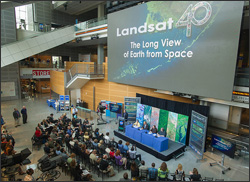
The panelists included NASA chief scientist, Waleed Abdalati; the Interior Department’s assistant secretary for water and science, Anne Castle; NASA Landsat project scientist, Jeff Masek; USGS senior scientist, Tom Loveland; NASA Landsat Data Continuity Mission project scientist Jim Irons; and USGS research geographer Roger Auch.
During the briefing, the 10 most significant images from the Landsat record were discussed along with the U.S. regions selected for the “My American Landscape” contest showing local environmental changes; and the top five Landsat “Earth As Art” images selected in an online poll.
Twenty-five social media enthusiasts attended the press conference as part of a NASA Social event. Afterwards they visited NASA Goddard Space Flight Center to learn more about Landsat and try their hand working with Landsat data.
“Over four decades, data from the Landsat series of satellites have become a vital reference worldwide for advancing our understanding of the science of the land,” said Secretary of the Interior, Ken Salazar, in a joint NASA-USGS statement, “The 40-year Landsat archive forms an indelible and objective register of America’s natural heritage…”
Landsat Anniversary articles:
+ Landsat at 40: The Long View of Earth from Space
+ NASA Portal: Landsat Looks and Sees
+ Forty Years of Observations Reveal a Changing Planet and Society
+ U.S. Celebrates 40th Birthday of First Earth-Observing Satellite
+ First of Three Million
Multimedia resources:
+ Watch Landsat@40 news conference
+ Top 10 Stories of Landsat’s 40 Years
+ My American Landscape
+ Earth as Art winners
+ Landsat@40 photos
+ NASA Goddard Multimedia
Landsat NASA Social photos:
+ Landsat @ 40 Social
Landsat at the ESRI Users’ Conference
+ USGS Rachel Headley’s presentation at the ESRI UC (see “Afternoon Session”)
Landsat Congressional Briefing (via AGU)
+ Fire, Food, and Water: 40 Years of Landsat Satellites
Sampling of outside event coverage:
+ MSNBC: Landsat celebrates 40 years of photographing our planet
+ Wired Magazine
+ Washington Post blog: NASA’s Landsat turns 40
+ Earth Imaging Journal: Celebrating 40 Years Years of Landsat
+ CNET: Landsat at 40: Images from the longest-running eye in the sky
+ Discovery News: Earth as Art from Space: Big Pic Gallery
+ The Atlantic: What 40 Years Have Wrought: The Earth Since 1972
+ The Christian Science Monitor: Landsat program marks 40 years of photographing Earth from space
+ BBC World News: Landsat Programme Celebrates Its Greatest Images On 40th Birthday
+ AGU: Impartial observers in space
+ Google Earth Engine

Be Part of What’s Next: Emerging Applications of Landsat at AGU24
Anyone making innovative use of Landsat data to meet societal needs today and during coming decades is encouraged to submit and abstract for the upcoming “Emerging Science Applications of Landsat” session at AGU24.


