Source: Rani Gran, NASA/GSFC; Jon Campbell, USGS; Roz Brown, BATC

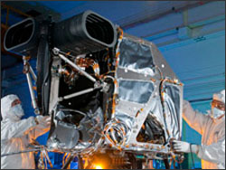
The Operational Land Imager (OLI), built by Ball Aerospace & Technologies Corp., Boulder, Colo., has been approved by NASA Goddard Space Flight Center for shipment to Orbital Sciences Corporation, Gilbert, Ariz. for integration onto the Landsat Data Continuity Mission (LDCM) spacecraft.
“OLI will be more sensitive to land cover changes and characteristics across the landscape and over time than previous Landsat instruments,” said James Irons, LDCM Project Scientist at NASA Goddard. “Analysts will be better able to identify and characterize land cover while also being better able to detect and monitor change.”
A multitude of scientific, commercial and governmental users rely on Landsat as their primary source of moderate-resolution, multispectral, image data. OLI will measure Earth’s reflectance in nine portions of the spectrum, including visible light, near infrared, and shortwave infrared, providing data that scientists and others use to quantify changes in Earth’s landscapes.
OLI images will cover wide areas of the Earth’s landscape while providing sufficient resolution to distinguish features like urban centers, farms, forests and other land uses. The OLI will provide Earth-imaging at 15-meter (49 ft.) panchromatic and 30-meter multispectral spatial resolutions along a 185 km (115 miles)-wide swath. The entire Earth will fall within view of the OLI once every 16 days from the near-polar LDCM orbit.
OLI represents advancement in Landsat sensor technology. Instruments on earlier Landsat satellites employed scan mirrors to sweep the instrument fields of view across the surface swath width and transmit light to a few detectors. The OLI will instead use long detector arrays, with over 7000 detectors per spectral band, aligned across its focal plane to view across the swath. The OLI design results in a more sensitive instrument providing improved land surface information with fewer moving parts. Engineers expect this new design to be more reliable while providing improved performance.
“OLI provides the key sensor technology to allow continuation of Landsat Earth observations into a fourth decade,” said Ball Aerospace president and CEO, David L. Taylor. “This continuation is essential to maintain seamless acquisition of Earth-from-space images not captured by any other private or public source.”

The Landsat program is a series of Earth-observing satellite missions jointly managed by NASA and the U.S. Geological Survey (USGS). For nearly 40 years, Landsat satellites have continuously and consistently collected images of Earth, creating a historical archive unmatched in quality, detail, coverage and value. Freely available Landsat data provide a unique resource for people who work in agriculture, geology, forestry, regional planning, education, mapping and global change research.
Landsat satellites capture unique Earth surface data vital to agriculture, water management, disaster response, scientific research, national security, and many other areas of societal benefit. “This is a crucial event for the LDCM mission and the Landsat Program,” said Bruce Quirk, USGS coordinator for the Land Remote Sensing Program. “OLI will provide the data continuity that the science community has depended on for nearly 40 years.”
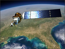
NASA plans to launch LDCM in December 2012 as the follow-on to Landsat 5, launched in 1984, and Landsat 7, launched in 1999. Both are continuing to supply images and data, but they are operating well beyond their designed lives and suffer limitations due to aging. As with preceding Landsat missions, the U.S. Geological Survey will operate LDCM and maintain its data archive once it reaches orbit and begins observations. USGS plans to change the name of LDCM to Landsat 8 when USGS takes over operations after launch and on-orbit checkout. Ball Aerospace & Technologies Corp. built the OLI instrument.
Orbital Sciences Corporation is building the LDCM spacecraft that will carry a two-sensor payload, the OLI and a Thermal Infrared Sensor (TIRS), into space when launched in December 2012. Integration of the spacecraft and the two sensors will occur prior to shipping the assembled LDCM satellite to the Vandenberg Air Force Base, California launch site.
Further Information:
+ NASA Press Release (includes video)
+ NASA LDCM Website
+ USGS Landsat Website

Undamming the Klamath
Between October 2023 and October 2024, the four dams of the Klamath Hydroelectric Project were taken down, opening more than 400 miles of salmon habitat.


