By Laura E.P. Rocchio
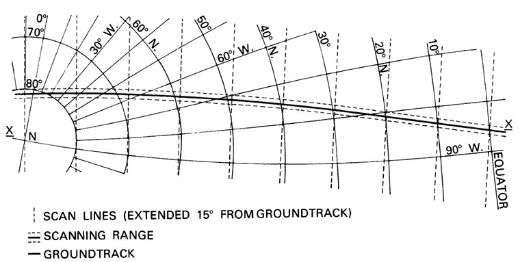
To continually map the Earth’s surface using Landsat data, an entirely new projection had to be created. This new projection was created by John Parr Snyder and is known as the Space Oblique Mercator (SOM) projection. It is considered, “one of the most complex projections ever devised” according to cartographic historian, John W. Hessler.
Excerpted from upcoming Landsat Legacy book:
Space Oblique Mercator: A new Map Projection for the Space Age
Referencing the centers of Landsat scenes to a map was not especially difficult; finding a way to lay actual scene data onto a map projection of the Earth was an entirely different matter, one that wouldn’t be completed until just prior to the Landsat 3 launch.
Upon recognizing that multispectral scanner (MSS) data could be used for cartographic applications, Colvocoresses (Colvo) and other cartographers realized there were no available map projections suitable for mapping Landsat data; the mathematical equations necessary to transform the data directly to common projections didn’t exist. An entirely new projection was needed—one that accounted for the Earth’s rotation and orbital precession together with Landsat’s orbit and the MSS scanner sweep. Colvo worked on the general geometry and named the conceptually-defined construct the Space Oblique Mercator (SOM) projection. The challenge was on to develop a SOM transformation equation with these variables.
The task proved to be extremely complex. Both NASA and USGS were unable to find a mathematical solution. At the 1976 conference “The Changing World of Geodetic Science” held at Ohio State University, chemical engineer and cartography hobbyist John Parr Snyder heard Colvo’s talk on the elusive SOM. But it wasn’t until the next year (after seeing a correspondence about the SOM between Waldo Tobler, a giant in the cartographic world, and Colvo) that Snyder decided to work on a SOM solution.
Snyder tackled the problem using only Texas Instrument-56 and -59 programmable calculators and a knowledge of ellipsoid geometry. His calculations for the SOM projection began with the most basic form of equations for the Mercator projection; he then created intermediate transformation equations that considered various movements of Landsat’s ground track as the satellite orbited the Earth. Iterating on these concepts until the SOM accounted for an elliptical Earth and orbits of any eccentricity, Snyder presented Colvo with the transformation equations for a spherical Earth in August 1977. Not long after, USGS hired Snyder and in 1978 honored him with their John Wesley Powell Award. Snyder’s final SOM solution is considered “eloquent” and crucial to transforming data collected by a satellite to any common map projection. Library of Congress Cartographic Historian John Hessler described the Space Oblique Mercator as “one of the most complex projections ever devised” and assessed Snyder to be “one of the most important mathematical cartographers in the long history of projection science.”
Further Reading:
+ Projecting Time: John Parr Synder and the Development of the Space Oblique Mercator Projection [PDF], by John Hessler, Geography and Map Division, Library of Congress
+ Get to Know a Projection: The Space-Oblique Mercator, Wired
+ Space Oblique Mercator Projection Mathematical Development, USGS Bulletin 1518, 1981
+ Space Oblique Mercator Projection
(added March 7, 2018):
+ History of GIS and Early Computer Cartography Project, ArcNews


